The Environment Agency is delivering a proposed Flood Risk Management Scheme to better protect homes and business from flooding in the Kent catchment, and improve the local environment and community amenities. Kendal is the first area to be delivered, followed by Burneside, Staveley, and Ings, and upstream measures including flood storage. In addition, Natural Flood Management measures are being integrated into the plans which aim to slow the flow of water and provide wider environmental benefits across the catchment.


Click here to return to Kendal Flood Risk Management Scheme page
The aim of the Kendal Flood Risk Management Scheme is to not only protect people and properties from flooding, but to create a lasting benefit for the community and the local environment. The Environment Agency plan to enhance the river corridor throughout the extent of the scheme through extensive landscaping, planting, and integrating a number of art features.
The Environment Agency will deliver art inspired by both Kendal’s heritage and Kendal’s future as a sustainable, vibrant, thriving town, where the river has shaped the landscape over time and will continue to do so into the future. The Environment Agency want to capture Kendal’s river history and memories of old to ensure this is never lost, whilst providing elements of new discovery, play and adventure through improved educational and recreational riverside spaces.
The flood scheme will incorporate a number of art and public realm benefits which will define improved community access areas, respect and capture the local history, and provide opportunity for new features such as signposting, seating and community led art integration. Here are some of the features that will be delivered as part of the scheme:-

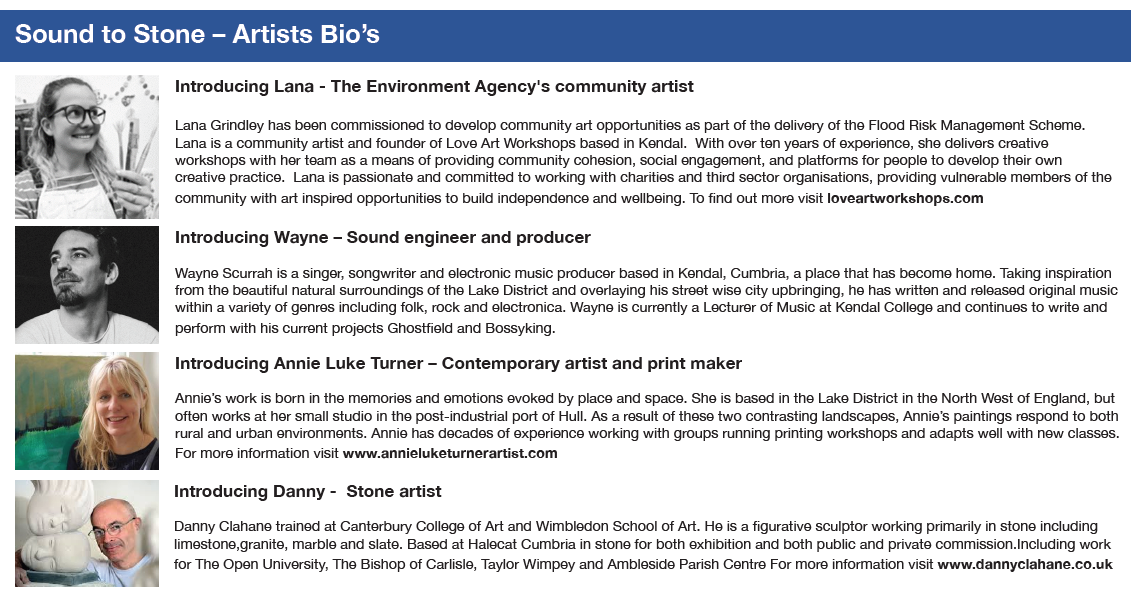
Lana Grindley has been commissioned by the Environment Agency to develop community art opportunities as part of the delivery of the Flood Risk Management Scheme. Lana is a community artist and founder of Love Art Workshops based in Kendal. With over ten years of experience, she delivers creative workshops with her team as a means of providing community cohesion, social engagement, and platforms for people to develop their own creative practice.
Lana is passionate and committed to working with charities and third sector organisations, providing vulnerable members of the community with art inspired opportunities to build independence and wellbeing. To find out more visit loveartworkshops.com.
Taking an inclusive approach to community art, the Environment Agency are involving older residents of the town to capture the riverside history, and working with younger people to capture ways to build understanding and awareness of the importance of creating a sustainable future.
Documenting the history, and the future of the river environment through art, will leave a positive legacy, telling the story of how the river and the climate have experienced adaptation and change over time, whilst looking forward to creating a more sustainable riverside corridor for the future.
Our aim in delivering the art project is to use materials that are sustainable, natural, reclaimed and locally sourced to be as environmentally friendly as possible.
The Environment Agency would like to introduce two of the educational art projects that will be delivered at Mintsfeet Footpath and Beezon Fields.
To celebrate Kendal’s industrial heritage and the importance of the River Kent, a wooden sculpture has been commissioned and will be placed on the grounds of the Parish Church replicating John Speed’s map. The wooden sculpture is being made from reclaimed timber from the local area and will be hand carved using traditional techniques.
The Speed Map sculpture will be a unique visual representation of the earliest map of Kendal, drawn by John Speed dating back to circa 1611-12. The sculpture will draw distinct links with the River Kent and its geographical importance as a road hub of the time. Kendal’s location with its links North and South, East and West provided huge opportunity for trade and industry, particularly that of the known wool industry of which Kendal has grown upon.
Whilst over the years Kendal has grown and developed, a number of key historical features of the map which still exist today and include;
To capture Kendal’s history, the Environment Agency is engaging with the town’s older residents by creating a memoir soundscape with Wayne Scurrah, a local musician. Interviews have captured their stories and childhood experiences of the river, touching on memories from the World War, industry and past flooding.
The information collected during these interviews will inspire artistic outcomes that captures and represents the memories and experiences of local people. This will be developed by working with Kendal College foundation art students and Space2Create, a local charity organisation, to create visuals and prints supported by a small team of local artists including Annie Luke Turner – a contemporary print artist.
All the visuals and prints developed during a number of workshops will be showcased at Kendal College Art Gallery in February 2022. Six visuals will be selected and these will be used by Danny Clahane, a local stone artist, who will produce engraved slate plaques that will be inlaid into the floodwall along Mintsfeet riverside footpath.
Michael Howard, Art & Design Lecturer has fully engaged his students with this project and said
“The Kendal College Art & Design department and students are very excited by the creative project provided by the Environment Agency. The opportunity for our students to collaborate and learn from local artists like Annie Turner and Danny Clahane helps give them first-hand experience of working in the creative industry. It will be such a positive experience for our students to see their designs incorporated into the flood defence scheme along the River Kent, to be enjoyed by locals and visitors to the area.”

Click here to read more
This area of land located to the north within the suburban fringe of Kendal, will be landscaped to become a new community nature area. The aim is to create a sustainable and thriving nature highway through art that conserves and improves the area for habitat and wildlife and creates an educational, discovery and play environment for local people and visitors.
The plan shows the diverse range of planting, landscaped in a way that provides a multitude of benefits as well as a number of educational and art features along a new sensory pathway, creating an inspiring place for discovery and play.

To view the full plan, including landscape and planting, click here.
The Environment Agency believe that everyone should have the opportunity to reconnect with nature and its amazing qualities. The sensory path will be a key feature offering a wide array of textures and sensations perfect for the discovery of wildlife. The pathway will guide you through the landscape along with an interactive nature trail. Carefully positioned art and planting will provide opportunities to stop and be in nature, with activities along the way to encourage the awakening of the senses through listening, looking, smelling, and touch.
Through the educational and sensory features like the interactive “rainwheel”, people of all ages will foster meaningful experiences with nature, developing a deeper understanding and appreciation of the natural world. The Environment Agency hope that skills gained here will be taken away by visitors and used in the greater outdoors and further along the beautiful river corridor which the Kent provides.
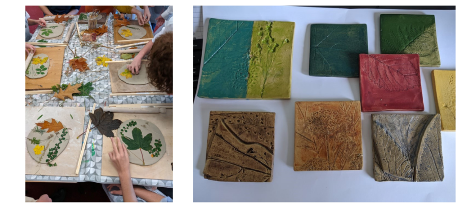
Another feature of the sensory path are the tactile mosaic tiles . These pieces of art have been made with local students from the town’s Sandgate and Castle Park Schools during sessions run by local ceramic artist Rosie Meredith. Promoting the sense of touch and vision, these colourful tiles will engage children with their local natural surroundings. The plant species used in designing these tiles have been found local to Kendal and some will be found in the Beezon Fields planting scheme.

The left image shows a Sandgate School workshop crating the tiles and the right image shows some of the finished mosaic tiles
To create a diverse habitat the scheme will also include living willow sculptures, in the form of arches and screens, designed and planted by local children through workshops run by local willow artists (Willowpool Designs). Willow structures absorb carbon dioxide, enrich the soil and provide new habitats whilst framing, dividing and creating spaces of interest for children to hide, seek and uncover their inner imaginations.
Stone seats have been hand carved from repurposed limestone which once formed part of the original Gooseholme Footbridge. These stone seats will comprise of the original footings and coping stones of Gooseholme Footbridge and will feature along the riverside on Beezon Fields.
The diverse planting includes areas of wildflowers including grassland and woodland species, and a variety of trees including fragrant species such as hawthorn, bird cherry and elder. The native plants selected will provide a tasty and much needed banquet for butterflies, bees and other insects.

Awareness is growing of the importance to sustain declining insect species by creating more habitats where they can thrive. Bug houses will be designed and positioned in key locations to help shelter insects that are key to pollinating the eco-systems. The landscaping and wildflower planting will create the ideal habitat to encourage, promote and support these vital species. The area will be sensitively planted to attract pollinator species, e.g. bees, butterflies and other insects.
Since the second world war, we’ve lost 97% of our wildflower meadows, leaving bees and other insects with little habitat in which to live. To celebrate the importance of our beloved humble bumble bee the Environment Agency will be commissioning a living bee sculpture, which will provide food for insects and raise the awareness of these issues. It’s vital that bees have enough food, flowers to forage and shelter to nest in and the Environment Agency hope that visitors will be inspired by this area building their own bee friendly habitat at home in their gardens.
Overall, the Environment Agency’s aim is to create an ideal spot to come and explore the River Kent and its surroundings and to embrace the art, wildlife and nature in and around it.

Click here to return to Kendal Flood Risk Management Scheme page