The Environment Agency is delivering a £54.7m Flood Risk Management Scheme to better protect homes, schools, and businesses along parts of the River Ribble. The Scheme will improve the local environment and community amenities too. Construction in Broadgate & Riverside, and in Lower Penwortham is the first phase. Further works will take place in Walton le Dale, Frenchwood & Fishwick, and Higher Walton.
The complex nature of delivering a flood scheme means that the Environment Agency has broken down the project into two phases, which are covering five areas. The order of work is influenced by minimising disruption and ensuring flood risk is managed.
The scheme will run from Broadgate and Lower Penwortham (starting close to Liverpool Road) along the River Ribble towards Frenchwood and Fishwick Bottoms, and across the river at Walton le Dale. Defences will also be constructed along the River Darwen in Walton le Dale and up towards Higher Walton.
Click here to download the document above.
Due to the scale of the project construction work will be phased over a three-year period. You can view a programme of works here.
You can read the latest news updates here.
Click here to return to the PSR Flood Risk Management Scheme Homepage
The flood defences along Broadgate and Riverside will be a combination of raised flood embankments, flood walls, and walls topped with glass panels. You can view examples of flood defences here.
Click here to return to the PSR Flood Risk Management Scheme Homepage
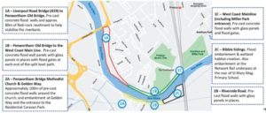
Replacement of the existing wall with a new concrete wall between Liverpool Road bridge and Penwortham Old Bridge.
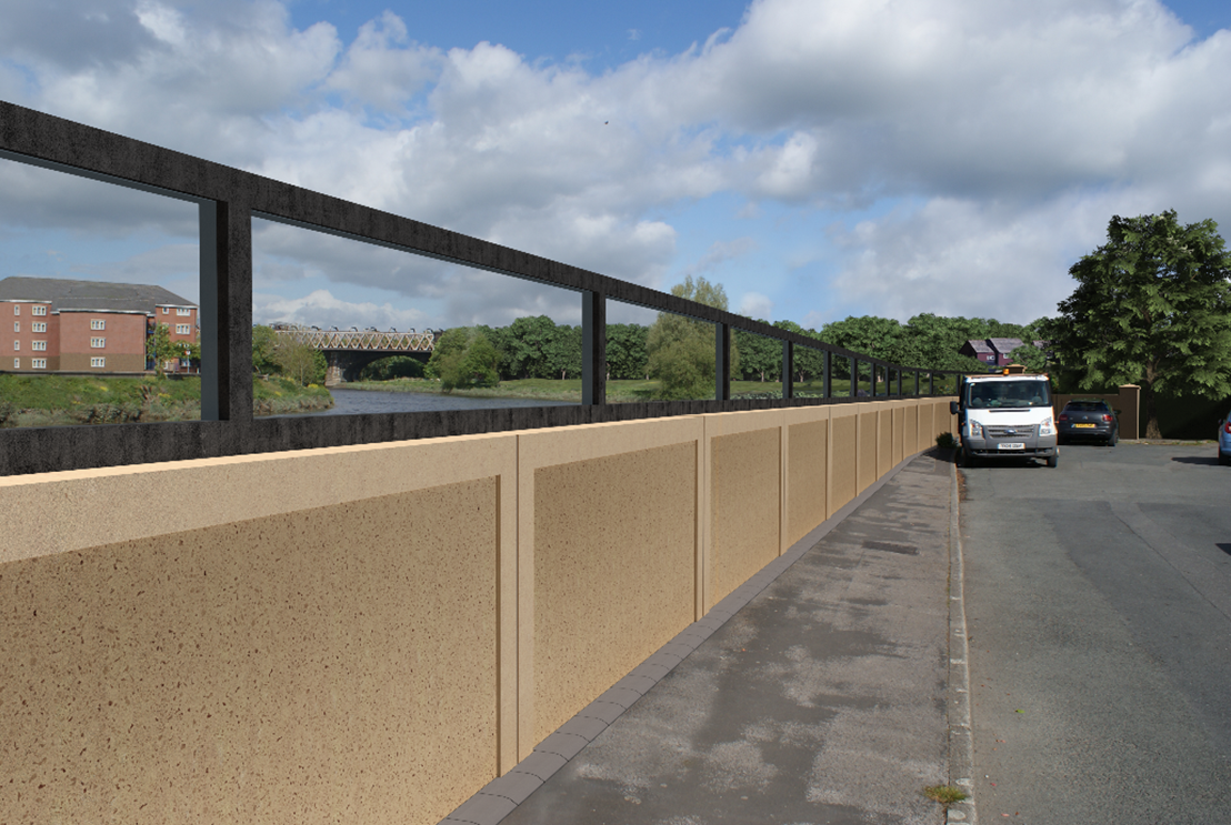
Replacement of the existing wall with a new concrete wall with glass panels on top along Riverside between Penwortham Old Bridge and Miller Gardens Apartments.
There will be a new flood wall along the boundary of the BAC/EE Preston Social and Sports Association cricket pitch plus safety fencing – the existing hedges will be removed. Flood gates will be installed near Ribble Cottage.
Replacement of the existing wall with a new concrete wall with glass panels on top along Riverside between the Ribble Cottage and the West Coast Mainline Bridge (WCML) including revetment towards the river. Defences from Ribble Cottage to WCML will include glass panels. Two flood gates will be installed at the entrance to Miller Park.
The flood defences will be a combination of raised flood embankments, flood walls, and walls topped with glass panels. You can view examples of flood defences here.
Click here to return to the PSR Flood Risk Management Scheme Homepage
Replacement of the old concrete flood defence wall, with a new pre-cast concrete flood defence wall and glass panels on top. The wall will run along Riverside Road from the Cadent Gas Pipe Bridge to Stanley Avenue (upstream end of Riverside Road).
There is some high ground in this area already. Only the entrances to the car parks of Penwortham Methodist Church, the PAGA allotments and Tinkerbells Day Nursery will be raised. A varying height flood wall will replace the fence and be built around the rear of the church.
The existing public right of way footpath, which is next to the church, will be raised to incorporate a flood defence embankment.
The flood defences will comprise of both walls and embankments from Riverside Road to the railway embankment.
It is proposed the flood defences along Frenchwood will be walls and embankments. You can view examples of flood defences here.
Click here to return to the PSR Flood Risk Management Scheme Homepage
As design work for the defences is finalised more information will be posted here.
Work in Walton le Dale will take place along the River Ribble (Area 3) and the River Darwen (Area 4). The flood defences will be a combination of raised flood embankments, pre-cast concrete walls, and walls with glass panels on top. You can view examples of flood defences here.
Click here to return to the PSR Flood Risk Management Scheme Homepage
The defences in this area will comprise of a solid wall with glass panels. The flood defences were previously improved here in 2004
In this area already, there are flood embankments and flood wall defences. It is proposed that there should be additional embankments, flood walls (some with glass panels).
There are currently flood embankments and flood walls in this area. It is currently proposed that all existing flood defences are raised here, this includes improving flood walls and adding glass panels in some places.
The flood defences will be a combination of raised flood embankments, pre-cast concrete flood walls, and walls topped with glass panels in places. You can view examples of flood defences here.
Click here to return to the PSR Flood Risk Management Scheme Homepage
As design work for the defences is finalised more information will be posted here.
Ahead of any construction, preparation works have to be carried out and this will involve moving services such as cabling or strengthening sewers. Until work on services is complete, constructing the flood defences cannot start. You can expect to see a number of service providers in flood scheme areas including, United Utilities, Electricity North West, and BT.
Some of the major relocation and service diversion works may require footpath closures / diversions and temporary lane closures on the highway. In addition, some of the working areas will need to be free from street furniture such as seating, bins, and street lighting. All street furniture will be restored on completion of the works.
The working hours approved through planning permission are 8am to 6pm Monday to Friday and 9am – 2pm on Saturdays. The Environment Agency and its construction partner VolkerStevin do not expect to work on weekends or public holidays.
Utility and service providers may have agreed different working times with the Council.
Unfortunately, some noise and dust will be created by the construction. However, we will monitor and manage noise, vibration, and dust levels and we will work to reduce any impact on homes, businesses, public areas, and the natural environment wherever possible.
Several monitoring techniques will be used and there will be a range of measures to provide visual screening, which will assist with reducing noise and dust levels.
To manage any debris on the roads, created by construction traffic, cleaning of the carriageway will be undertaken by a road sweeper or similar, as appropriate.
The working areas will be compact, balancing the need to keep contractors and the community safe while minimising disruption. In some areas there will be dedicated routes for bringing in materials and plant to the site compound area and then distributing from the site compound to the various work areas.
Diversions and closures will include:
The Traffic Management Plan has been developed with Lancashire County Council Highways, who will ensure any temporary road or lane closures are managed appropriately to minimise traffic disruption.
Click here to return to the PSR Flood Risk Management Scheme Homepage