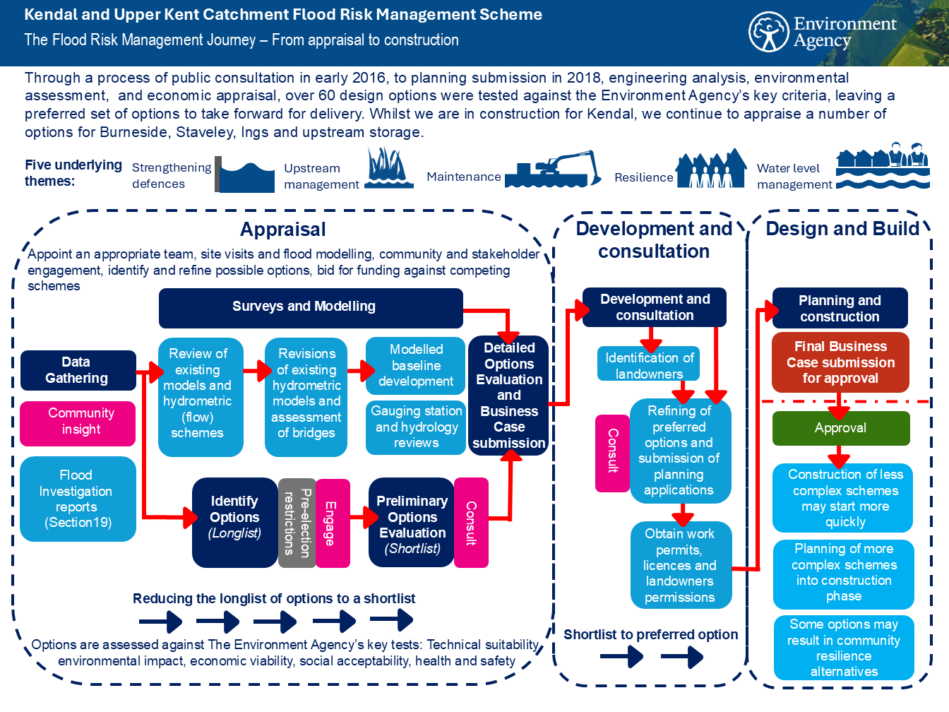
 Kendal has a long history of flooding which was experienced most recently during Storm Desmond in 2015, when 2,276 properties and businesses were flooded in Kendal, Burneside, Staveley and Ings. Since then, the Environment Agency along with Westmorland and Furness Council (formerly Cumbria County Council and South Lakeland District Council), United Utilities and other professional partners including the local community identified over 60 different options to address the complex flood issues that affect the catchment. Each option was considered for their technical feasibility, economic viability, environmental sustainability and social acceptability. The preferred option was presented in September 2018 and later received planning approval in June 2019. Construction of the flood scheme in Kendal started in Feb 2021 and aims to be complete in 2025/6.
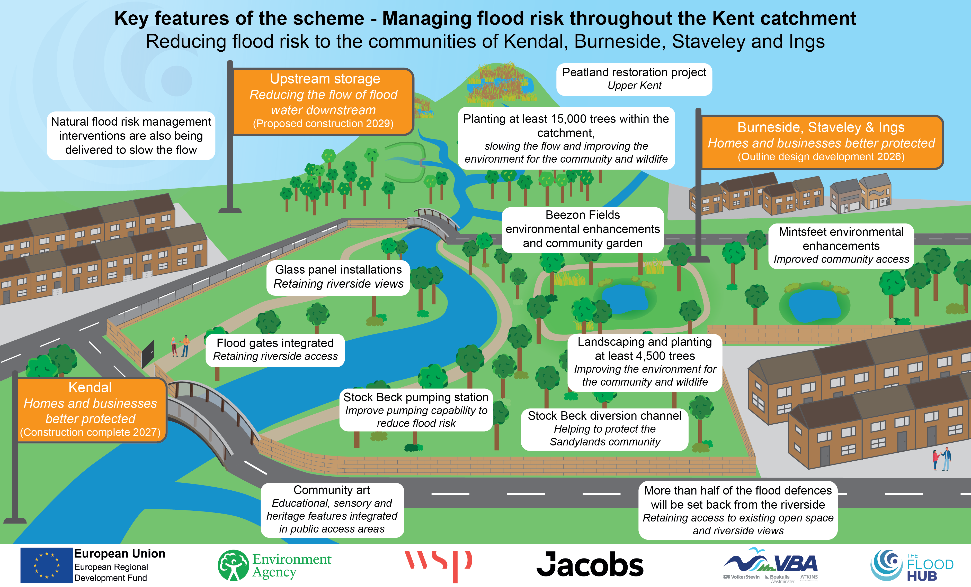
The preferred option takes a catchment based approach and includes a combination of linear defences, improved pumping and conveyance, upstream storage, complimentary natural flood management interventions and wider environmental improvements. Multi-million pounds worth of construction will better better protect over 1921 homes and 2250 businesses directly and indirectly from flooding in Kendal, Burneside, Staveley and Ings. For information on Burneside, Staveley and Ings and upstream measures, click here.
Taking a catchment based approach the Flood Risk Management Scheme will be delivered through the Kent catchment as follows:
Kendal Flood Risk Management Scheme
- Currently in construction, Kendal will benefit from a combination of raised linear defences and improved conveyance that will protect homes and businesses from flooding. Over 6km of flood defences extend from Mintsfeet in the northern end of the town to Helsington Mills in the southern end of the town.
Burneside, Staveley and Ings Flood Risk Management Scheme
- The Flood Risk Management Scheme will protect homes and businesses most at risk in the communities of Burneside, Staveley and Ings. The scheme currently in early design will identify targeted engineered solutions, environmental improvements and landscaping enhancements.
Upstream Storage, Improved Conveyance, and Natural Flood Management (NFM)
- Flood storage is a fundamental element in the scheme design as it will hold excess water in the upper catchment, controlling the volumes of water flowing through Kendal, Burneside, Staveley and Ings during flood conditions. With controlled volumes of water flowing through the villages and Kendal, bridges, roads, drainage systems, communication and utility services have greater resilience and will be better protected.
- A catchment drain from Stock Beck East and North into the River Mint is proposed to reduce the risk of flooding from Stock Beck in the residential area of Sandylands in Kendal.
In addition to engineered upstream storage, Natural Flood Management measures will complement the scheme by slowing the flow and improving habitat in key locations.
These are important elements to complete the scheme, each providing a number of flood risk benefits and playing a vital role in managing excess flows from the upper reaches of the catchment.
For more information on Burneside, Staveley and Ings, and Upstream Measures, click here.
Journey Map to Delivery