Information on this page has been provided by the Environment Agency and was correct at the time of upload. The Flood Hub is not responsible for any information held on this page.
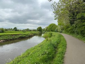
Image showing channelisation of the River Mersey through South Manchester. Image: Environment Agency
The River Mersey (flowing through the South Manchester Catchments) contains a significant number of Environment Agency maintained Flood Risk Management assets which are approaching the end of their design life.
Some of the main assets are:
The current management approach involves regular investment in the maintenance of significant lengths of raised earth embankment and revetment which channelise the watercourse, disconnect the river from its floodplain, and which defend only flood plain and recreation / amenity land. This does not align well with current Environment Agency (EA) objectives, targets and aspirations.
The study area was hit heavily by Storm Christoph in January 2021. A major incident was declared and approximately 2,000 properties were evacuated despite the country being in national lockdown due to Covid-19.
A similar event occurred in February 2022 when Storms Eunice and Franklin resulted in the operation of both flood storage basins and record river levels being reached at this location for a second consecutive year. Many Environment Agency assets were damaged in the event resulting in a programme of post flood recovery works amounting to approximately £2.5million.
The current approach to managing flood risk within the study area was endorsed by the 2004 Flood Defence Strategy Plan, which identified a number of phases of works to maintain and / or improve formal flood defences which protect key urban areas in South Manchester; to continue the operation of the two flood storage basins and to maintain a number of key weir structures. In addition, the current Flood Risk Management approach includes maintaining significant lengths of raised embankment and revetment which channelise the watercourse and defend only flood plain and recreation / amenity land.
The first two phases of work identified in the 2004 Flood Defence Strategy Plan were successfully implemented. These initial phases included localised improvements to flood defences in the densely populated areas in East and West Didsbury, Northenden and Heaton Mersey; and remedial works to Northenden and Sale Ees weirs.
However, it is now acknowledged that this previous Strategy Plan is outdated and doesn’t align well with the current EA objectives and targets to achieve Net Zero Carbon by 2030; to maximise potential opportunities for Biodiversity Net Gain and to promote the delivery of WFD mitigation measures.
The current maintenance regime for assets within the study area have now deviated from the 2004 Strategy Plan for several reasons including operational Health and Safety concerns and increasing forecast construction costs. Maintenance activities of key assets are now primarily based on a reactive approach.
In recognition of this, the EA is currently progressing the River Mersey (South Manchester Catchments) strategy project, which has two main objectives:
Objective/Stage 1: Understand the existing Flood Risk Management Assets.
Objective/ Stage 2: Identify a long-term Flood Risk Management approach.
The River Mersey (South Manchester Catchments) Strategy project has two key objectives, which are being delivered in two separate project stages:
The outputs of Stage 1 will be used to develop an Asset Management Plan(s) in accordance with ISO 55000 to effectively manage and operate these assets until a new Flood Risk Management approach has been identified and adopted.
Stage 1 of the project is currently forecast to be completed in winter 2025/26.
Stage 2 of the project will follow on from Stage 1 and its primary output will be the identification of a preferred approach for the future long term (100 years) management of flood risk within the study area.
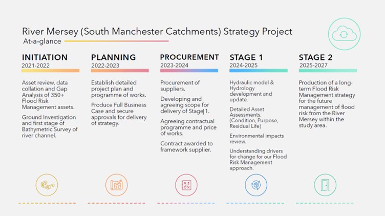
Programme Timeline summary
Any potential physical works to assets in the study area will not be delivered as part of this Strategy project but will be completed by subsequent projects set up to deliver the recommendations of the Strategy project.
Alongside the Strategy Project there are other flood risk management activities ongoing within the River Mersey (South Manchester Catchments) area. These include works being carried out to repair Northenden Weir, as well as Asset maintenance activities along the embankments of the River Mersey.
More information about the repair works at Northenden Weir can be found by clicking the link below:
Repair Works at Northenden Weir | The Flood Hub
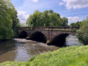
Cheadle Bridge, River Mersey. Image: Environment Agency
The New Years Day floods resulted in erosion of the embankment along several locations. Emergency works are currently underway to protect the banks where there have been breaches, to enable us to operate the basins as they previously operated.
As it stands, the basins would fill from the river and still provide storage and benefit but the rate at which they fill is less controlled. Work has progressed well and the main job of placing large bags to create a protective barrier is almost finished. The Environment Agency will update this further when repairs are complete.
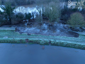
Breached embankment following Ney Years Day Floods in January 2025. Image: Survey Operations on behalf of The Environment Agency
Following the community drop‑ins held in November 2025, the project team has continued work on Stage 1 of the strategy. We have now received the consultants’ findings for this stage, and we are currently reviewing and verifying the information.
We had initially planned to hold further community drop‑ins and Councillor briefings in March 2026. However, preliminary national guidance has confirmed that the pre‑election period will begin on 16 April ahead of the Local Elections on 7 May 2026. To ensure we can share fully verified Stage 1 results and provide enough time for open discussion, we will now be holding these engagement events in mid‑June.
We understand that this date change is disappointing, but rescheduling will help ensure that everyone has fair access to the latest information and that we can engage openly with residents, stakeholders and elected members.
We will share the confirmed dates and venues for the June events as soon as arrangements are finalised.
The first stage of the River Mersey Flood Risk Management Strategy continues to progress in line with the programme and remains on track for completion by the end of November 2025.
Since the last update, the project team has finalised an environmental assessment of the current approach to flood risk management. This has included evaluating potential impacts on biodiversity, landscape, and heritage, as well as considering how future flood risk management could better align with sustainability goals.
Initial findings suggest that the existing approach may not fully support the Environment Agency’s ambitions for cost efficiency, carbon reduction, or achieving Net Zero Carbon by 2030. The study has also highlighted opportunities to work more closely with natural processes to create a more adaptive and resilient flood risk management system.
Recent flood events have further emphasised the importance of reviewing how flood risk is managed across the study area. Site surveys have identified areas where realigning flood defences and reconnecting the river with its floodplain could reduce flood risk while also delivering wider benefits for people and wildlife.
These insights will help shape the next stage of the project. Preparations for Stage 2 are underway, with an anticipated start in early 2026.
However, this remains dependent on future funding decisions, which have not yet been confirmed for the 2026/27 period.
Engaging with local communities and stakeholders is a key priority for the project. The Environment Agency have developed a detailed stakeholder engagement and communications plan to ensure that residents, businesses, local authorities, and other interested parties are kept informed and have meaningful opportunities to shape the strategy.
Whilst some early engagement has already taken place, the majority of this activity will happen during Stage 2, when the Environment Agency will be exploring and consulting on long-term options for managing flood risk. This collaborative approach will help ensure the final strategy reflects local priorities, builds consensus, and delivers wider social and environmental benefits.
Stage 2 will focus on identifying a preferred long-term (100-year) approach to managing flood risk in the study area, with completion currently forecast for Autumn 2027.
The strategy may recommend changes to current flood defence operations, including:
The project team remains committed to developing a strategy that is sustainable, adaptive, and aligned with the Environment Agency’s long-term objectives.
The Strategy Project is currently progressing in line with the programme. The Environment Agency (EA) are undertaking a comprehensive assessment of their flood defence assets, focusing on their current condition, structural integrity, and estimated residual life. This includes embankments, flood walls and other key infrastructure components.
An updated hydraulic model has been developed using the latest LiDAR topographic data, 3D bathymetric survey, hydrological inputs, and asset survey data. The model has been calibrated and verified against recent flood events to ensure accuracy and reliability.
The EA are now entering the scenario modelling phase. This involves simulating a range of fluvial flood events under varying return periods, incorporating climate change allowances in line with EA guidance. These simulations will assess the performance of existing flood defences and identify residual risk across defined Flood Cells within the study area.
Stage 1, which encompasses data collection, model development and baseline risk assessment, is currently forecast for completion before the end of 2025.
Subject to securing the necessary funding, Stage 2 of the project is scheduled to commence this winter (2025/26) and will focus on the identification of a preferred approach for the future long term (100 years) management of flood risk within the study area.
Stage 2 of the project is currently forecast to complete in Summer 2027.
During Stage 2 the EA will consider it’s future approach to flood risk management within the study area and where necessary make strategic adjustments to the current approach to ensure that practices align with corporate objectives and aspirations.
The new strategy may recommend a significantly different approach to current flood defence operations. The strategic review will challenge the need for retaining extensive lengths of embankment and revetment that protect only amenity land; investigate the ongoing need for the two existing flood storage basins; confirm locations where existing defences need future proofing against the impacts of climate change; and explore the wider environmental benefits of reconnecting the watercourse with the natural flood plain.


