Information on this page has been provided by the Environment Agency and was correct at the time of upload. The Flood Hub is not responsible for any information held on this page. For any enquiries, see the Contact section of the page.
Ribchester is a historic village and former Roman settlement situated in the Ribble Valley, Lancashire. Ribchester is at risk of flooding from the River Ribble, Boyce’s Brook and Duddel Brook – as well as localised areas of surface water. The village has experienced flooding on several occasions in recent times including 2012, 2015, 2020 and 2023.

Map of Flood risk areas
In December 2015, 18 properties along Greenside and Ribblesdale Road were reported to have flooded during two major storm events, via a combination of the River Ribble, Boyce’s Brook and Duddel Brook.
On 9th February 2020, it is estimated that 24 properties along Greenside and Ribblesdale Road flooded from the River Ribble, Boyce’s Brook and Duddel Brook. The recorded rainfall and extreme height that the River Ribble eventually reached were not forecast in the lead-up to the event. Consequently, there was insufficient time to install the existing temporary defence deployment plan (TDDP).
On 6th October 2023, 1 property on Ribblesdale Road flooded from surface water occurring when a culvert beneath the Ribchester Social Club surcharged as a result of high levels with Boyce’s Brook. Although there was only a singular incident of internal property flooding, considerable highway flooding occurred both along Ribblesdale Road and Blackburn Road adjacent to the Ribchester Arms Pub.
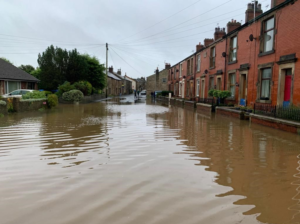
Image 2: Highway flooding to Ribblesdale Road following 6th Oct 2024 flood event.
An Environment Agency (EA) Temporary Defence Deployment Plan (TDDP) previously existed for Ribchester. The TDDP consisted of approx. 200m of metal A-frame barriers topped with polythene sheeting membrane, which required a lead time of 24-48 hours to safely deploy. These temporary defences offered a level of protection to properties along Greenside who experienced flooding caused by high water levels on the River Ribble and the lower sections of Duddel Brook. The temporary flood barriers did not manage flooding from Boyce’s Brook or surface water.
In October 2022, a review instigated by the need to bring all deployment plans in line with the Construction and Design Management (CDM) Regulations 2015 resulted in the withdrawal of the TDDP. The review found that the additional lead time required by flood forecasting now needed to safely and effectively deploy the barriers in line with CDM was unachievable (48-72 hours) in such a rapidly-responding catchment.
A sandbag store and wheelbarrow remains in situ on open ground at the junction of Greenside and Blackburn Road for residents to utilise during a flood event.
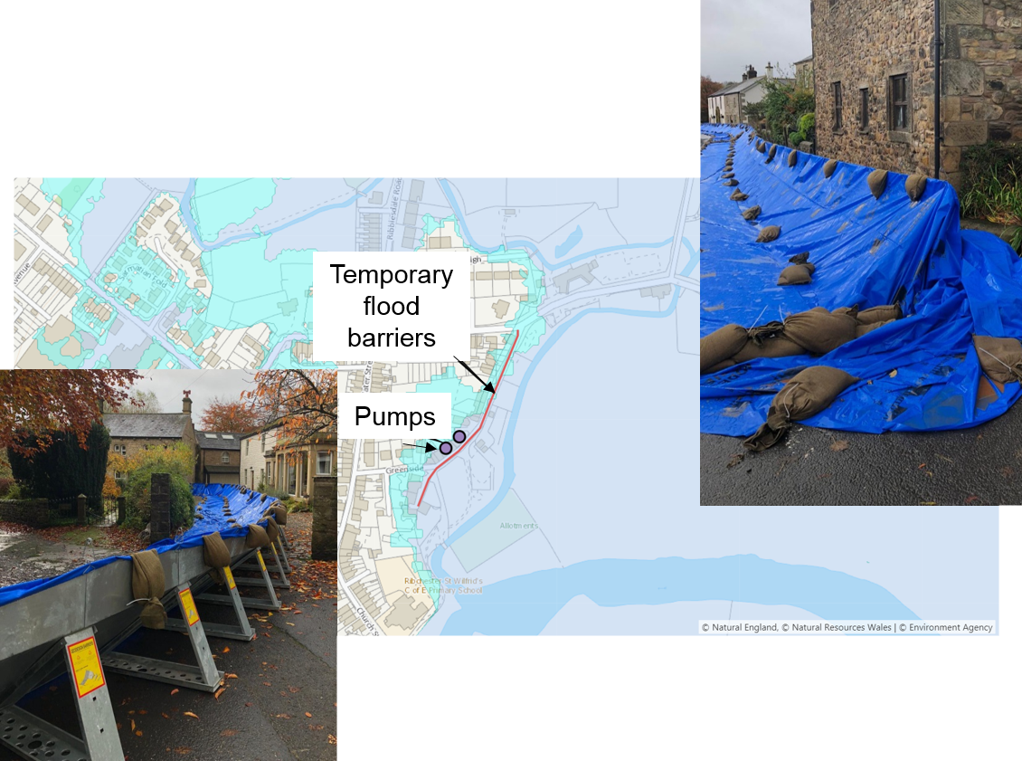
Image 3: Temporary defences deployed along Greenside
Ribchester is covered by two separate EA Flood Warning Areas (012FWFL5 & 012FWFL69) which alert residents based on predicted river levels from the River Ribble and Boyces Brook respectively. Residents can sign up to these flood warnings here.
An existing earth embankment on land adjacent to Boyces Brook offers a level of protection from the watercourse. Landowners are responsible for informal walls, high riverbanks and structures within their curtilage. More information on owning a watercourse can be found at https://www.gov.uk/guidance/owning-a-watercourse.
The EA have developed initial proposals for permanent flood risk management schemes in the village on several occasions. However, following further investigations, these proposals have been unable to meet the necessary Flood Defence Grant in Aid cost-benefit and partnership funding criteria to secure funding to design and deliver a scheme.
The EA are presently seeking to update the existing hydraulic modelling for the Ribchester catchment, which will incorporate updated hydrological data recorded during recent storm events. This project will help determine if properties are at a more significant flood risk than previously indicated, information which could be used to justify further assessments of capital funded interventions in the future.
A catchment based approach of slowing the flow via upstream management is promoted and undertaken by the EA. Upstream of Ribchester there have been natural flood management projects directly involving the EA at Trawden and Long Preston Deeps. The Environment Agency’s partners, such as the Ribble Rivers Trust, have ambitious plans to create vast amounts of new woodland over the coming years. This will all help to slow the overall water flow into the River Ribble from the land. More information can be found at https://ribbletrust.org.uk/news/press-releases/rivers-trust-launches-10-year-campaign-to-double-area-of-lancashires-woodlands/.
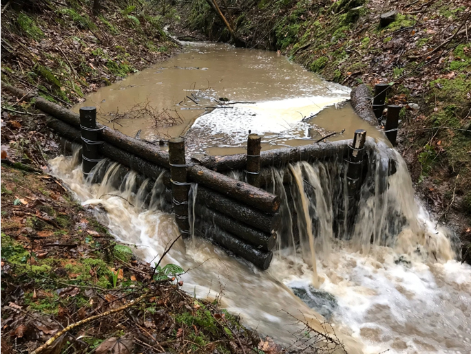
Image 4: Example of leaky dam structure often utilised in NFM works
The EA’s local Partnership and Strategic Overview (PSO) team also continue to work in partnership and explore opportunities to collaborate with key stakeholders including Ribchester Ecology and Flood Group, Ribchester Parish Council, Ribble Rivers Trust, Ribble Valley Borough Council, Lancashire County Council and United Utilities.
A joint survey of Ribchester residents between the Environment Agency and Ribchester Parish Council was carried out in December 2023 to determine if data held on past flood events and existing Property Flood Resilience (PFR) measures in the village could be improved. The survey established that the records currently held by the Environment Agency on past flooding were largely accurate. Survey results also provided useful information on the distribution of PFR and individual’s experiences with PFR products that could help inform any approach in the future. More information on PFR can be found via the Be Flood Ready website.
The aim of the continued collaborative work is to increase flood resilience in the village, improve planning, preparation and communication as well as seeking to deliver local flood management measures on Boyce’s Brook and Duddel Brook.

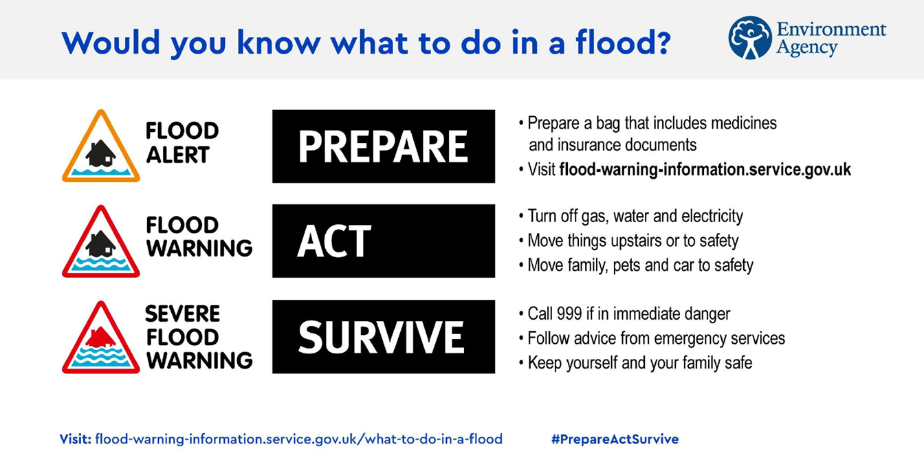
Flood Alerts and Warnings continue to be monitored and issued. Community members at risk of flooding are encouraged to sign-up for these at https://www.gov.uk/sign-up-for-flood-warnings.
More information regarding flood resilience can be found at https://www.gov.uk/help-during-flood.
A collaborative Natural Flood Management (NFM) scheme involving the EA, Ribble Rivers Trust and the Ribchester Flood and Ecology group is working to implement NFM measures across the wider Ribchester Catchment. This scheme has targeted the watercourses of Boyces Brook, Duddel Brook and Stydd Brook, as well as their respective tributaries.
Beginning in 2025, joint funding from the EA and Ribble Rivers Trust has enabled the creation of leaky dams on Duddel Brook and attenuation ponds on farmland draining to Boyces Brook. Additionally bespoke NFM hydraulic modelling of the catchment has been completed which will help estimate the cumulative impact that a wide range of NFM interventions will have on slowing the flow, and reducing downstream flood risk. These modelling results will also enable the project team to strategically target land parcels most suited to specific NFM techniques such as leaky dams, attenuation ponds, and riparian tree planting.
Funding for the continuation of this project throughout 2026/27 has been secured from the Community Foundation for Lancashire and the Ribble Valley Jubilee Fund. This will enable the project team to further engage prospective landowners and fund the construction of additional NFM measures. Ribble Rivers Trust will also work directly with volunteers from Ribchester Flood and Ecology to measure the impact of these interventions on river flow in the village.
No extra downloads at this time
No extra downloads at this time
Reporting Flood incidents (“Floodline”): 0345 988 1188
Reporting Environmental Incident: 0800 80 70 60
Sign-up for Flood Warnings: https://www.gov.uk/sign-up-for-flood-warnings
General enquiries or issues email: [email protected]
General enquires or issues telephone: 03708 506 506
Post (please note that teams are mostly working from home during the current Covid-19 pandemic. Please allow for more time if contacting the team via post):
Environment Agency – PSO Team
Lutra House, Dodd Way, Walton Summit, Preston, PR5 8BX
Partners
Report highway flood issue: https://www.lancashire.gov.uk/roads-parking-and-travel/report-it/ (Lancs County Council) or 0300 126 6701
Report public sewer flood issues: 0345 672 3723 (United Utilities)
Risk to life: 999
Sign-up for flood warnings: https://www.gov.uk/sign-up-for-flood-warnings
Check your preparations for flooding: https://www.gov.uk/help-during-flood


