Information on this page has been provided by Wirral Council and was correct at the time of upload. The Flood Hub is not responsible for any information held on this page.
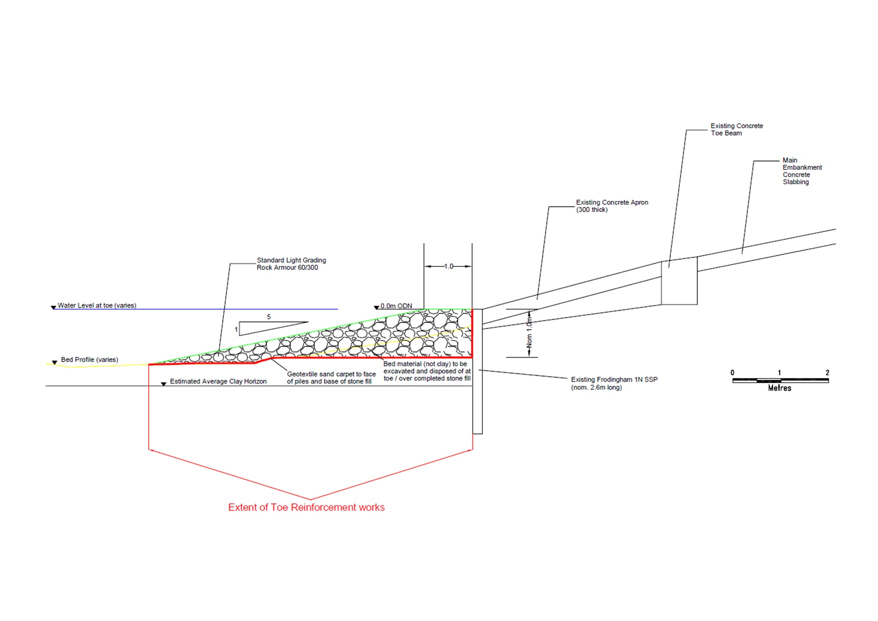
This scheme was completed in August 2022. The scheme involved the importation and placing of approximately 7,000 tonnes of rock armour along approximately 1.1km of the toe of the Wallasey Embankment, to prevent undermining of the existing coastal defence structure. Over the next 30 years, until such time that further embankment improvement works may be required, the scheme will deliver over £58 million in flood risk reduction benefits for an estimated capital outlay of approximately £1.36 million.

The Wallasey Embankment is a 3.5km long sloping sea wall and promenade that provides flood and erosion protection to large parts of the North Wirral hinterland, specifically large parts of Leasowe, Moreton and Meols.
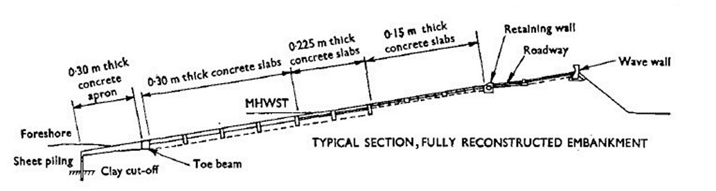
The original Wallasey Embankment structure between Meols and Leasowe was constructed in the mid-19th century for the purpose of preventing a breach in the natural dune belt that would have flooded a large area of hinterland. The embankment was reconstructed during the 1970s and 1980s.
The Meols channel has historically meandered across the frontage providing a tidal inlet/outlet to the open sea for the Meols and Hoylake areas of Wirral
Changes in the position of the channel have been monitored and charted since the 1970s. Growth of East Hoyle sandbank has caused the outlet of Meols channel to move further eastwards and a consequential change in position to the base of Wallasey Embankment.
In the late 1990s Wirral Council placed a rock toe directly in front of the toe piles over approximately 350 metres where the channel had increased the risk of undermining of the embankment. Since that time further monitoring of beach profiles and channel movement has been undertaken.
The North West England and North Wales Shoreline Management Plan, approved by Wirral Council Cabinet in 2010 identified a Hold The Line Policy for the whole of the Wallasey Embankment. The subsequent Wirral Coastal Strategy, approved by Cabinet in October 2013, identified that extension of existing toe protection works of the embankment were likely to be required in the short to medium term to mitigate the impacts of the Meols channel running along the toe in the vicinity of Leasowe Lighthouse. The Wirral Coastal Strategy also reviewed the Expected Residual Life of Wallasey Embankment, which identified that without intervention and with the potential for Meols channel to undermine the toe, an Expected Residual Life less than 20 years could be expected.
The foreshore directly in front of the embankment is internationally designated of conservation and environmental importance, with the following statutory environmental designations applying:
Given the environmental designations applying and that the works will encroach within the designated environmental sites, the minimum requirements for any scheme of works is consent under the Habitats Regulations and the EU Habitats Directive (HRA) and approval under the Water Environment (Water Framework Directive) (England and Wales) Regulations 2003 (WFD). Whilst an Environmental Impact Assessment was not required the application for Planning Consent required both Habitat Regulations Assessment and Water Framework Directive Assessment. Planning consent was granted in December 2020.
A marine licence application was made to the MMO in June 2020. The MMO granted a Marine Licence in July 2021.
With all environmental issues addressed, an Outline Business Case (OBC) was prepared and submitted to the Environment Agency in December 2021. The OBC identified a failure of the embankment because of the increased erosion risk would increase the risk of flooding from the sea to 1,269 households in the neighbouring areas of Leasowe and Moreton. The OBC, informed by the Habitat Regulations Assessment undertaken for the Planning Consent also identified the preferred option as the extension of the existing rock armour toe protection by placing 7,000 tonnes of rock armour along 1,100m of unprotected toe to Wallasey Embankment.
The number of properties with improved protection because of the scheme is significant when compared to the estimated scheme costs.
The OBC was approved in March 2022 by the Environment Agency and provides grant in aid for the full project estimate of £1,358,000.
A procurement exercise was undertaken in May 2022 to appoint a Contractor to deliver the scheme whilst complying with Planning and Marine Licence conditions of completion by end of August 2022.
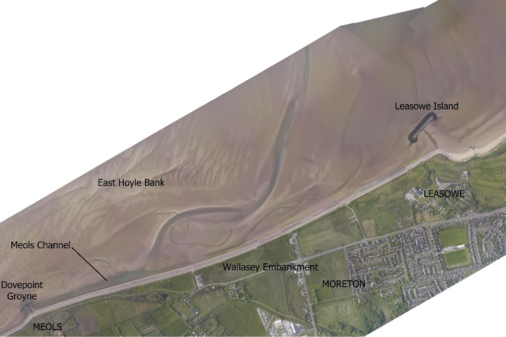
Aerial view of East Hoyle Bank showing Wallasey Embankment (Pre Business Case Report by Coastal Engineering UK Ltd in 2019) Aerial Photography and Sediment Information is subject to an open government licence. Any re-use of the data must credit the North West and North Wales Coastal Group through the North West Regional Monitoring Programme www.coastalmonitoring.org