The Environment Agency are working with partners to design a new Flood Risk Management Scheme for Fleetwood. The planned scheme would reduce flood risk to 3,095 residential and 447 non-residential properties.
Thus far, the Environment Agency has developed a list of options to manage flood risk in Fleetwood, and these have been assessed in accordance with Flood and Coastal Risk Management Appraisal Guidance. A new linear flood defence, from the northeast end of Dock Street towards the Southwest end of Bridge Road, was identified as the preferred option.

Plan showing 2 different possible alignment options for the new Flood Risk Management Scheme. The final design will likely follow an alignment in between the two.
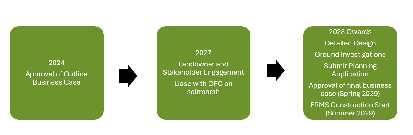
The appraisal of Flood Risk Management Schemes requires a phased approach. The Environment Agency have completed the Outline Business Case and in 2027 are looking to move onto the Full Business Case. This is when the detailed design elements of the preferred option, including its construction type, alignment and finish are considered. Partners and members of the public will have the opportunity to provide their thoughts and opinions and where possible, this will be used to inform the design.
The Fleetwood FRMS will provide a consistent standard of protection along the Wyre Peninsula, against a flood event with a 0.5% (e.g. a 200 to 1 chance) of occurring in any one year. The scheme has included for the effects of climate change, with consideration given to the impacts of sea-level rise and increased magnitude and severity of flood events. This increases the resilience of the scheme to climate change and reduces the requirement for further intervention in the medium to long-term.
As the scheme progresses, updates will be made by the Environment Agency to this page on The Flood Hub website and we will engage with communities and other stakeholders, keeping them updated via newsletters and public drop in events where people can talk to partners about the proposals.
Our Future Coast project – Fleetwood
In the Outline Business Case the Environment Agency presented an option that included replacing a section of steel sheet piling at Jubilee Quay. This was included as the existing sheet piling is believed to be in a poor state and could not be relied upon to provide the stability required to construct a flood defence behind it. Since submitting the Outline Business Case, the Environment Agency have continued to engage with partners and understand that alternative methods of stabilising the quayside are available.
Working with the Our Future Coast Project, the Environment Agency will also be considering the option to stabilise the existing quayside through the creation of saltmarsh in front of the sheet piling. This could provide us with the same level of assurance that should the quayside fail, the new flood defence would not be put at risk.
For more information about the wider Our Future Coast project, including at Jubilee Quay, please follow the link: Our Sites | The Flood Hub.
Project Timeline 
*Dates are indicative and based on the current programme