The Environment Agency is delivering a proposed Flood Risk Management Scheme to better protect homes, businesses and communities from flooding across the Kent catchment, while improving the local environment and community amenities.
Kendal Town is the first area to be delivered, with the upstream communities of Burneside, Staveley and Ings, including flood storage, forming later stages of the scheme. In addition, Natural Flood Management measures are being integrated into the plans which help slow the flow of water, store water in the landscape, improve habitats and biodiversity, whilst providing wider environmental benefits across the catchment.
Please scroll down for further information.
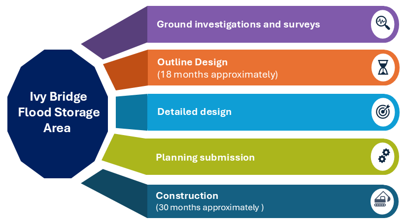
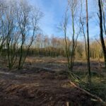
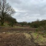
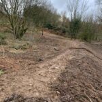
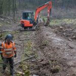
Flood storage is an essential part of the Kendal and Upper Kent Flood Risk Management Scheme. To progress the outline design of the proposed flood storage area, the Environment Agency first need to build a detailed understanding of the ground conditions and underground features.
Click the image to view a larger version
The Environment Agency is continuing a programme of surveys and investigations at Ivy Bridge. These studies will provide essential information to help shape and refine the design of the proposed flood storage area.
For more information, click here – January 2026 Newsletter
Click here – Autumn 2025 Newsletter
The Environment Agency’s key tests are used to determine whether a flood risk management scheme – as well as each individual measure – is economically viable, technically feasible, environmentally sustainable, socially acceptable and safe to deliver. Applying these tests enables the Environment Agency to design solutions that provide an improved standard of protection, delivered in the right place, at the right time.
In combination with the proposed flood storage area at Ivy Bridge, for the upstream communities of Burneside, Staveley and Ings, the results of the mini assessments and economic reviews demonstrated a need for a bespoke approach to flood risk management for each village.
Rather than relying solely on traditional hard‑engineered defences, the assessments showed clear opportunities to explore a mix of tailored solutions, including:
This combination of measures aims to deliver bespoke schemes shaped around need, characteristics and community priorities.
The Environment Agency are committed to working with a wide range of landowners, organisations and local partners to bring forward projects that improve biodiversity, restore habitats, infrastructure, river conveyance and help manage flood risk across the catchment. Varying in scale and focus, this could include restoring watercourses and wetlands, deliver natural flood management measures, and improve biodiversity.
The Environment Agency are keen to work with others to explore new opportunities, if you’re interested in developing a project or discussing opportunities to work together, they’d love to hear from you.
Click the image to view a larger version
Building on the Adaptive Pathway approach, the Environment Agency is working with landowners and partners across the catchment to deliver and support a wide range of Natural Flood Management (NFM) and environmental projects.
These solutions will help manage flood risk in a changing climate while creating opportunities to enhance habitats, improve water quality and support local wildlife. This collaborative approach aims to build a long‑lasting, climate‑ready and sustainable future for communities and the environment.
NFM focuses on working with natural processes to slow, store and filter water. Typical measures include tree planting, leaky dams, soil and land management and wetland creation, all designed primarily to reduce flood risk.
The Environment Agency aim to build on these techniques, combining traditional NFM with minimal engineered solutions and environmental improvements to deliver additional benefits that go beyond flood mitigation through the scheme.
These projects may include habitat and river restoration, peatland and landscape recovery, floodplain reconnection, carbon storage and water‑quality enhancements. Together, they support biodiversity, strengthen climate resilience and help restore natural ecosystems, while contributing to effective flood management.

Click the image to view a larger version

The Environment Agency is working with partners and landowners across the Upper Kent catchment to deliver Natural Flood Management (NFM) projects that slow the flow, improve habitats and help reduce flood risk. A number of projects have already been completed in Cumbria, each contributing to a healthier, more resilient landscape.
As part of the Cumbria Peat Partnership, and in collaboration with Cumbria Wildlife Trust, the Environment Agency has committed to restoring 50 hectares of upland peatland in the Kent catchment.
Peatlands, formed from Sphagnum moss, play a vital role in both climate and water management. Once restored, they can store significant amounts of carbon, support specialist upland species and naturally slow the movement of water during heavy rainfall. This programme alone could store around 164 tonnes of carbon dioxide each year while also helping to reduce flood risk.
Much of the Lake District’s blanket bog has been degraded over time. Restoration work – such as re‑vegetating bare peat, blocking historic drainage channels and increasing Sphagnum cover – helps rebuild these important upland ecosystems.
Healthy Sphagnum can hold up to 26 times its own weight in water, making peatland restoration a powerful natural tool for managing water sustainably and supporting long‑term climate resilience.
Further projects are planned for delivery across the Kent catchment that will further enhance the environment and reduce flood risk to properties downstream.
Multiple Benefits of Peatland Restoration
Restoring peatland delivers a wide range of environmental benefits that go far beyond reducing flood risk.
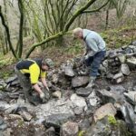
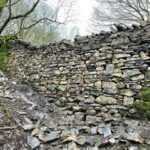
The Environment Agency has worked with South Cumbria Rivers Trust to deliver a three‑phase project, designed to ‘test and trial’ new techniques for reducing flood risk in rural communities. The work focuses on natural, low‑impact interventions that help slow, store and divert water during heavy rainfall.
Key measures include:
These techniques aim to improve resilience in rural areas while also supporting local biodiversity and natural river processes.
For more information, please visit the South Cumbria Rivers Trust website.

Leaky dam

Culvert

Kerplunk feature
South Cumbria Rivers Trust worked with Westmorland and Furness Council, The Environment Agency and landowners to deliver an urban NFM project at Town View Fields in the heart of Kendal. The project site is being used to test how effective and viable NFM techniques are in urban areas to reduce peak flows during storms events. Some aspects of the project include:

Construction of new channel

Example “Kerplunk” attenuation feature
The Environment Agency worked Cumbria Wildlife Trust, United Utilities and local landowners to reduce flood risk to the Kendal community using natural solutions rather than traditional engineered defences. By creating wetter habitats and planting a diverse mix of trees, the project is improving water management while also enhancing the ecological value of the area.
Working with Farmers
The project included close collaboration with the farming community to explore practical measures that help slow the flow of water. This included sub‑soiling, which improves soil structure and water infiltration, and re‑routing flows away from pressure points to reduce the impact of heavy rainfall.
Work on United Utilities Land
On land owned by United Utilities, and with support from Kendal Conservation Volunteers, a series of natural interventions have been installed to help manage water during storm events. These include:
Tree planting was also a major part of the project, with 7,100 trees already planted and over 500 more planned. Species include Sessile Oak, Hazel, Rowan, Aspen, Hawthorn and Cherry, with Crab Apple, Bird Cherry, Blackthorn and Goat Willow planted around the upper reservoir area. This mix helps create a resilient woodland that supports wildlife and improves long‑term water management.
Permitted pathways run through the site, but visitors are asked to avoid walking on the flood management structures, so they remain effective over time.


Images provided by the Environment Agency
The LifeR4EverKent Project is a £4.5 million programme, funded through the European Union’s LIFE Programme, running from October 2021 to January 2027. The project aims to restore and revitalise the River Kent, ensuring the river system can better support its species and become more resilient to the impacts of climate change.
Partner organisations include Natural England, the Environment Agency, the Freshwater Biological Association and South Cumbria Rivers Trust, working together to deliver improvements across the catchment.
The project forms a key part of wider efforts to restore natural river processes, enhance biodiversity and build long‑term resilience for the Kent’s unique and protected river environment.
For further information about the project and to watch a short film highlighting the length and breadth of the work please click here.
Project information can also be found on the GOV.UK website here.

The following projects are being delivered under the LifeR4EverKent Project:
As part of the partnership, the Environment Agency has committed to delivering 1.9km of river restoration within the Kent catchment. This work will help protect and create suitable habitats for some of the river’s most vulnerable species, including fish, freshwater pearl mussels and white‑clawed crayfish.
The Dubbs Beck restoration project has now been completed after nearly three years of work. Delivered in partnership with the South Cumbria Rivers Trust (SCRT), Natural England, Biffa Award and the EU LIFE IP Natural Course programme, the project set out to restore a straightened section of Dubbs Beck, a tributary of the River Gowan in the Kent catchment, so that it can function as a more natural river system.
The project focused on a 375‑metre stretch where past embankments and revetment had restricted the beck’s ability to move and shape its own channel. Removing these structures has allowed the river to develop more natural flow patterns, improve habitat diversity, and encourage the natural movement of sediments. New fencing was installed to reduce bank erosion and support sustainable livestock management.
In late 2023, one of the final pieces of work involved installing a new agricultural bridge. After the revetment was removed, the beck widened naturally, meaning the old bridge could have become a pinch point during high flows. The replacement bridge provides safe access while allowing the beck to flow freely and operate more naturally. Additional fencing and guardrails were also added to protect the restored area.
Volunteers played an important part in the project. Large trees were planted upstream, and a further 75 trees were added along the restored section. As these trees establish and grow, they will provide valuable habitat, improve shade and cover, and help support a healthier river corridor.
More information and a time-lapse of the restoration work can be viewed here.
The Environment Agency are exploring opportunities to deliver further re-engagement to maximise the flood plain and improvement to habitats and biodiversity.
The Environment Agency worked with South Cumbria Rivers Trust to restore natural river processes at Grassgarth, an important part of the Upper Kent catchment, and a designated Site of Special Scientific Interest (SSSI) and Special Area of Conservation (SAC). The project aimed to enhance biodiversity and reduce flood risk for nearby communities.
Works included opening culverts, creating scrapes and planting trees to improve flow conditions and strengthen connectivity across the floodplain. Restoring this section of the river also supports natural water storage during heavy rainfall, helping to build long‑term climate resilience.
This project forms part of a wider programme of collaborative work to improve river health, restore habitats and create environmental benefits across the Upper Kent catchment.
Landscape Recovery (LR) is described by DEFRA as the ‘Top Tier’ of Environmental Land Management Schemes (ELMS). It supports large-scale, long-term projects that restore nature, improve biodiversity and deliver environmental benefits across whole landscapes in England.
LR Projects bring together farmers, landowners, environmental organisations and local communities to create plans tailored to their local area, focussing on ambitious environmental goals while at the same time aiming to strengthen rural communities and make space for nature alongside food production. By combining government funding with private investment, projects can be more ambitious, spread risk, and open new income streams for farmers and landowners.
Projects are given a two-year funded development phase to create plans that will explain in detail how they will work together over the next 20 years to achieve their goals and ambitions. These plans are then considered by DEFRA and if successful, projects will secure 20 years of ELM funding.
Penrith to Kendal Arc (P2K) Landscape Recovery Project
Covering approx. 16,500Ha, the Penrith to Kendal Arc (P2K) project area covers multiple watersheds (Eden, Kent and Lune) and supports a huge array of wildlife. The Northern half of the project area is centred on the River Lowther, where lowland farms and woodlands rise up into fells and moorland, including the largest expanse of blanket bog in the Lake District.
The Southern part of the project lies in the catchments of the River Sprint and River Kent. The valleys of Kentmere and Longsleddale, with their rich hanging woodlands, fast-flowing rivers and agricultural and mining history provide huge opportunity for enhancing habitat connectivity from the high fells down into Kendal. Over 80% of the project lies within the Lake District National Park.
Managed through a collaboration between the Lowther Farming Partnership and Cumbria Connect, the project brings together nearly 40 farmers and landowners to restore nature at a landscape scale. To date, the Environment Agency have been engaging with the project and landowners to support suitable river and wetland restoration projects that will improve water conveyance, create new habitat and biodiversity across the Kent catchment.
The project is part of Defra’s second round of Landscape Recovery, designed to support long‑term, collaborative land management that improves the environment while sustaining productive farming.
The project aims to:
P2K has written and submitted its plans and is now in the DEFRA Assurance phase.
Haweswater Landscape Recover Project – also known as ‘Wild Haweswater’
The Haweswater Landscape Recovery Project, often referred to as Wild Haweswater, is a major nature restoration project in the eastern Lake District, focused on improving the landscape for wildlife, water and people.
It covers around 3,000 hectares of land surrounding Haweswater Reservoir, which supplies drinking water to more than 2 million people across the North West.
Led by a partnership between RSPB, United Utilities and supported by the Environment Agency, the project is transforming the area into a healthier, more resilient landscape. Work includes restoring rivers, rewetting peatlands, expanding woodlands, and promoting nature friendly farming. For example, the team has ‘re-meander’ the once straightened Swindale Beck, helping improve water quality, reduce flood risk, and bring back wildlife, such as Atlantic salmon.
The project is part of the wider Cumbria Connect programme, which aims to connect and restore nature across tens of thousands of hectares across eastern Cumbria, helping to create healthier habitats, support threatened species like water voles and red squirrels, and strengthens the landscape’s resilience to climate change.
Wild Haweswater has written and submitted its plans and is now in the DEFRA Assurance phase.
Click here to read more.
The Environment Agency and their partners aim to restore the natural river systems by reversing manmade features such as weirs and small dams.
Many manmade features prevent the natural river flow and no longer serve their original purpose. They are often no longer maintained by their owners, which can lead to deterioration, and in some cases, increase damage to the natural riverine environment and flood risk to nearby communities.
By assessing the condition of these structures and the surrounding river environment, the Environment Agency can identify where their removal will deliver the greatest overall benefit.
Removing redundant structures helps restore natural river flow, allowing water to move more freely and reducing the likelihood of blockages during high flows. It also improves water quality, as oxygen levels and natural cleansing processes are enhanced once the river is able to function without barriers.
Reinstating natural flow patterns also improves sediment movement, which supports healthier riverbeds and banks. This, in turn, boosts biodiversity by creating better habitats for fish, invertebrates and plants that depend on a naturally functioning river system.
From a flood‑risk perspective, removing failing or unnecessary weirs can reduce pressure on existing defences and help the river respond more effectively during storm events. Over time, this supports a more resilient river system that can better adapt to the impacts of climate change.
Weirs of all sizes are currently being assessed, and the Environment Agency will continue working with owners and local communities to understand the risks, opportunities and long‑term benefits of maintaining, modifying or removing these structures.
Built over 150 years ago, Barley Bridge Weir is thought to sit on bedrock and to have been constructed using timber and stone typical of the era.
In December 2025, localised storms generated high flows that caused part of the weir to collapse. With no known owner, the Environment Agency and Westmorland and Furness Council are jointly monitoring the situation.
The Environment Agency is focusing on potential flood risk and environmental impacts arising from further deterioration or the release of sediment and gravels. Westmorland and Furness Council is monitoring any effects on nearby bridge and road infrastructure.
As part of the wider Kendal and Upper Kent Flood Risk Management Scheme, the Environment Agency has carried out a structural survey to assess the condition of the weir; results are currently under review. A drone survey completed in January 2026 has provided additional up‑to‑date information on the condition of the weir and its impact on the river environment.

Barley Bridge Weir Failure Point 15th December 2025

Barley Bridge Weir Failure Point 19th December 2025

Barley Bridge Weir – 14th January 2026
South Cumbria Rivers Trust in collaboration with the Environment Agency and Natural England has successfully delivered a weir removal on the River Kent at Bowston, a location near Burneside in South Cumbria.
The weir removal forms part of a highly acclaimed Cumbria River Restoration programme, which aims to restore and improve the rivers for the benefit of people and wildlife. The weir removal is significant due to its size and scale, with this being the largest weir removal within the country to happen during 2022. Since the removal, the river has already shown improvements in form and function and will continue to improve as a designated Site of Special Scientific Interest (SSSI), and a Special Area of Conservation (SAC).
Find out more about this project:
Watch the YouTube video here.
Jeremy Wade, renowned fisherman visits Bowston and explains the importance of projects like this – YouTube
The programme of works has been funded by the European Agricultural Fund for Rural Development.
Ford Bridge Replacement Burneside
Working closely with Cumbria County Council (now Westmorland and Furness Council), the Environment Agency helped deliver the new Ford Bridge which opened in 2019. The council invested £1.5 million through its Infrastructure Recovery Programme after the original structure was badly damaged by Storm Desmond in 2015 and closed in 2017.
The new bridge:
The bridge has been designed to be more resilient to future extreme weather events and will allow more water to flow under the bridge which will help reduce the overall impact of any future flood events.

Ford Bridge – damage during Storm Desmond 2015

Ford Bridge Improvement
Staveley Bridge Replacement
Cumbria County Council invested around £500,000 as part of its Infrastructure Recovery Programme into the Staveley Bridge replacement project which was completed in May 2017. Old Gowan Bridge was severely damaged by Storm Desmond in 2015 and the new structure was designed to increase resilience and increase the volume of water able to flow beneath it.

Before: Gowan Bridge, Staveley – photo provided by Cumbria County Council

After: Gowan Bridge – photo provided by Cumbria County Council

After: Gowan Bridge – photo provided by Cumbria County Council
Burneside Wall Repair
Remedial works have been carried out to repair the flood defence wall running along the boundary of the Bridge Street car park, adjacent to the James Cropper Plc factory. A structural inspection and monitoring process indicated that movement between two sections of the wall caused a crack to form. As part of the works the team have installed an expansion joint to allow for natural movement and ensure long‑term stability.

Burneside Wall Repair
Burneside Sewer Upgrade Burneside Sewer Repair Works
As part of their works to increase the sewer network capacity and help address sewer flooding, United Utilities propose to replace approximately 820 metres of sewer to install new large diameter pipes and increase the size of existing manholes. Work is expected to start in Spring 2025, with completion expected in early 2027.
Click on the following links to find out more.


