Introduction
Hambleton is a village within the Borough of Wyre on the Fylde coastal plain in Lancashire. It sits alongside the River Wyre and between two smaller watercourses, Wardleys Pool and Pegs Pool.
Hambleton and its community are at flood risk. A large part of the village is in flood zone 3 which is an area with the highest probability of flooding. At present, the chance of flooding in any one year is greater than or equal to 1% (e.g. a 100 to 1 chance) for river flooding and greater than or equal to 0.5% (e.g. a 200 to 1 chance) for coastal and tidal flooding. The risk of flooding in Hambleton is likely to increase in the future as a result of climate change. Globally, intense storms are becoming more frequent and climate change is already increasing sea levels around the UK coast

View of the River Wyre from Pegs Pool
Scheme Details
The Environment Agency are working with partners on a new flood risk management scheme for Hambleton. The scheme will reduce flood risk to over 600 properties.
A list of options to manage flood risk in Hambleton was developed and assessed in accordance with Flood and Coastal Risk Management Appraisal Guidance. For further details on all of the options considered as part of the Hambleton FRMS please see the Frequently Asked Questions section, question 8. The preferred option of constructing raised flood defences was identified as the most feasible and cost effective option.
The existing defences, extending from the Shore Road to the embankment in front of Hambleton Fisheries, do not provide a consistent standard of protection. The defences in the south provide protection for a flood event with a 1% chance of occurring in any one year. In contrast, the defences in the vicinity of The Shore provide protection for a flood event with a 50% chance of occurring in any one year.
Linear flood walls are proposed from Kiln Lane, north of Wardleys Pool, to the end of the existing embankment near Peg’s Pool. The Hambleton FRMS will provide a consistent standard of protection against a flood event with a 0.5% chance of occurring in any one year. The scheme has included the effects of climate change, with consideration given to the impacts of sea-level rise and increased magnitude and severity of flood events. This increases the resilience of the scheme to climate change and reduces the requirement for further intervention in the medium to long-term.
As the main FRMS works will affect protected saltmarsh habitat along Hambleton’s frontage, a compensatory habitat site will also be delivered as part of the scheme. These measures, located off Rawcliffe Road, will need to be in place before the construction of the new flood defences starts in Hambleton.
The works at the compensatory habitat site involve the construction of a new flood defence wall and the breaching of an existing embankment. This breach will enable tidal waters to inundate the site which in turn will encourage an inter-tidal habitat to establish. The project team has worked closely with Natural England in developing the design of the site and this consultation will continue to ensure that the new habitat establishes in the desired manner.
The proposed flood defences are subdivided into 5 zones:
- Zone 1: Wardleys Yacht Club, running adjacent to Kiln Lane, to the junction between Kiln Lane and The Shore.
- Zone 2: Junction between Kiln Lane and The Shore, running adjacent to The Shore, to the southern extent of The Shore.
- Zone 3: Southern extent of The Shore, running adjacent to residential gardens, to Pedder Lane footpath.
- Zone 4: Pedder Lane footpath, running on the line of Peg’s Pool embankment, to the southern extent of Peg’s Pool embankment.
- Zone 5: Rawcliffe Road Compensatory Habitat site

Proposed location of defences
The planning application for the Hambleton Flood Risk Management Scheme was heard by the Local Planning Authority (Wyre Council) on 4 December 2024.
Wyre Council have granted conditional planning permission for the scheme.
The Decision Notice can be viewed on Wyre’s planning portal here. The Decision Notice lists the conditions which the Environment Agency must satisfy. The Environment Agency Project Team are currently working towards discharging these conditions.
Construction at Hambleton will not be starting in Spring 2025 as planned. Work is ongoing to finalise our delivery programme, and a further update will be shared in the coming weeks.
In the meantime, the Environment Agency project team will continue to be available to the community, contactable via the usual channels, and will be continuing work to refine their scheme as they look to address their planning conditions and set up to deliver the project at the earliest opportunity.
Preservation of Hambleton’s complex habitats has been a key objective of the project as is meeting targets for Biodiversity Net Gain (BNG), click here for information about BNG. The Rawcliffe Road compensatory habitat site will offset the temporary and permanent impacts on the existing Saltmarsh habitat, and proactive tree planting has taken place on Saltmarsh Lane to compensate for vegetation loss that will arise from the construction works. Where trees and hedgerows need to be removed to enable construction, new trees and hedgerows will be planted in greater numbers than before.
While the Environment Agency’s project team has identified and designed measures to satisfy the requirements for compensatory habitat, planting and BNG, it remains keen to identify further opportunities for environmental enhancement in the vicinity of Hambleton as part of the scheme, and welcome interest from local landowners to identify further planting opportunities.
If you would like to discuss this opportunity further, please email [email protected].
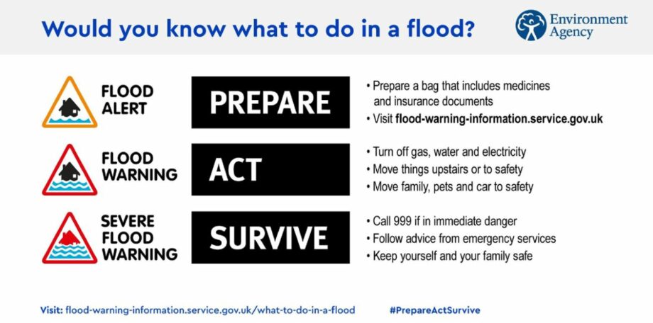
The Environment Agency continue to improve and offer a Flood Warning Service. Forecasts and gauges are continually monitored, and Flood Alerts and Warnings are issued for the River Wyre as necessary. Community members at risk of flooding are encouraged to sign-up for these at https://www.gov.uk/sign-up-for-flood-warnings.
More information regarding flood resilience can be found at https://www.gov.uk/help-during-flood.
Communications and Engagement
The Environment Agency are committed to engaging and consulting with the community regarding the scheme proposals.
Public engagement events were held during 2018 and 2019 to seek feedback on the scheme proposals which the Environment Agency’s project team has sought to address in the detailed design.
While the detailed design phase has spanned across the COVID-19 outbreak and associated restrictions, the Environment Agency has sought to maintain contact with the community and the project stakeholders. For a time, this, engagement was primarily online, in the form of email responses to enquiries and providing community-wide scheme updates via this page and newsletters.
Since the COVID-19 restrictions have been lifted, the project team has met landowners and residents face to face to discuss issues and pursue opportunities and continue to respond to individual enquiries received on-line.
More recently, the project team hosted an engagement event in June 2023. Members of the project team were in attendance and were delighted by both the number of attendees and keen interest shown in the proposals.
Updates regarding progress on the scheme will be provided via this website and the Hambleton Newsletter, which will be circulated to those who have previously expressed interest in scheme updates via the Hambleton Flood Risk Management Scheme mailing list. If you would like to sign up to the mailing list, please email [email protected].