Phasing of Work
We are delivering a flood risk management scheme
that extends from Helsington Mills in the south of Kendal to Mintsfeet in the north.
The complex nature of delivering a long linear scheme through a busy town centre has led us to break down the scheme into a number of small sections we term as ‘reaches’. The map shows the locations of the different reach areas where works have been and will be occurring.
The order of work is influenced by minimising impacts to traffic and pedestrian movement within the town whilst ensuring we manage flood risk.

Phasing of work map (click to expand)
Keeping Kendal Moving
The working areas will be compact, balancing the need to keep the contractors, the community and visitors to the area safe. Some footpaths along the riverside will be temporarily closed whilst works take place in those areas, but alternative footpaths will be open in line with our Traffic Management Plan.
All road bridges will remain open for access at all times. There will be temporary lane closures on Aynam Road and on New Road. A road closure will be in place at Waterside whilst work takes place in these areas.
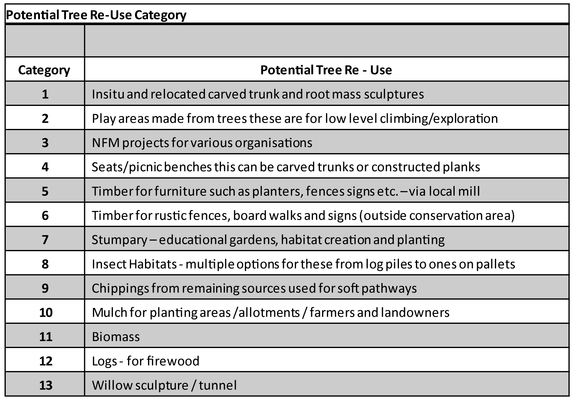
Preparing for Construction: Tree Removal and Re-use
Tree assessment and appraisal process
The tree assessment process is detailed and ongoing throughout the design and construction phases. As part of the assessment process, mitigation measures are identified ahead of any construction works and also the determination of the re-use options of wood from all felled trees and branch removal.

Tree assessment and appraisal process (click to expand)
A range of techniques will be used in order to manage the tree and vegetation removal on site ahead of any construction works.
Trees that will be retained – Tree protection barriers will be installed to minimise the risk of damage to tree root systems, branches and trunks from soil compaction, contamination, construction works or vehicles.
Vegetation clearance and pruning – Ground covering vegetation will be removed to ensure the working area is clear. Some trees will require pruning to ensure there is safe clearance and space to work but will be protected from further impact. If trees are pruned they will be retained.
Coppicing – This is a process of cutting trees down to ground level and allowing the stumps to regenerate new growth over a number of years. This technique enables the tree to remain.
Soft felling – This approach will be used on trees that have been identified through the assessment process to have bat roosting potential. Soft felling will be undertaken outside of the bat roosting season. This technique involves removing small sections of the tree, carefully lowering to the ground and leaving overnight to provide an opportunity for bats to vacate the tree.
Felling – For tree removal (other than those to be soft felled) a sensitive approach will be taken to ensure limited impacts. Any trees that need to be felled will be done outside of the bird nesting season and appropriate checks will be made on site for any active nests prior to removal works.
The Environment Agency continue to assess the removal of any trees as a consequence of the scheme and continue to work hard to reduce this number. To date, through further assessments and refining the scheme design, the number of trees identified for removal has reduced from 779 to around 500. Work continues to reduce this number further.
Working Arrangements
Preparing for construction
Ahead of any construction there will be a number of preparation works to carry out. In some locations the Environment Agency are able to deliver the construction works more easily due to larger working areas, the works not being complex in their nature, and because there is little interference from underground services.
There are a number of locations however, particularly in the central areas, where a number of preparatory works are needed before construction can begin.
All the working areas need to be free from utility services and street furniture such as seating, bins and street lighting. Where it is known where underground services are located and street furniture and lighting needs to be removed, preparations are being made with the service providers to divert or undertake removal and relocation works. Some of the major relocation and service diversion works may require footpath closures / diversions and temporary lane closures on the highway.
Working hours
The approved working hours will be Monday to Saturday from 8am to 6pm however, the EA’s aim is to work from Monday to Friday only. It is not anticipated that work will take place outside of these hours but if required, additional permissions will be applied for.
Minimising construction noise & dust
Throughout the construction of the scheme noise and dust levels will be monitored and managed to reduce any impact to homes, businesses, public areas, and the natural environment. Several monitoring techniques will be used and a range of measures to provide visual screening will assist with reducing noise and dust levels.
To manage any debris on the roads created by construction traffic, a full clean of the carriageway will be undertaken by a road sweeper or similar at a frequency that is appropriate.
Piling activities
Piling is an activity which will take place is locations where we need to create a strong foundation from which the new flood walls will be constructed. Piling can cause noise and vibration impacting homes and businesses within the vicinity. Noise and vibration mitigation will be in place during these works and will be consistently monitored to ensure levels remain within agreed tolerances.
Construction traffic
There are dedicated routes for bringing in materials and plant to the site compound area and then distributing from the site compound to the various work areas. The construction traffic and delivery routes will access Kendal from Junctions 36 and 39 of the M6.
The compound area is located at Gilthwaiterigg Lane in the north of the town. The compound is also used to store materials and has office and site welfare facilities.

Compound area