Introduction
Whalley & Billington are villages in the district of Ribble Valley, Lancashire, situated along the banks of the River Calder. These communities have experienced significant flooding, with the earliest recorded flood event dating back to 1866. Most recently flooding has occurred in 2015 and 2020.
On 26th December 2015, 136 properties in Whalley (196) and Billington (40) flooded as a result of Storm Eva, when the River Calder exceeded its channel capacity. The water levels taken at the Whalley weir river gauge were the highest on record and the flood extent was the greatest for 150 years.
On 9th February 2020, approximately 104 properties in Whalley (70) and Billington (34) flooded as a result of Storm Ciara. Although river levels did not exceed those in 2015 on this occasion, they still resulted in the second highest levels ever recorded.
Alongside flooding from the Calder, Whalley has also experienced flooding via a smaller watercourse, Wiswell Brook, which becomes culverted under King Street. The interactions between these watercourses, when combined with surface water and the former Mill Race, exacerbates flood risk for neighbouring properties.
In Billington, the low-lying residential area around Longworth Road is the most frequently flooded area of the village. Flood Risk is exacerbated by natural topography and constraints caused by Whalley railway viaduct and the A59 road bridge.
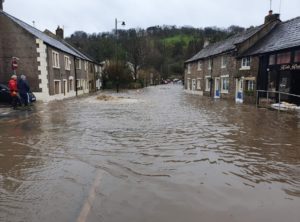
Image 1: Flooding of King Street, Whalley during February 2020 storm event
Flood Risk Management Overview
Several partner organisations have been working together for a number of years to plan and implement better flood risk management in Whalley and Billington. This includes the Environment Agency, Lancashire County Council, Ribble Valley Borough Council, United Utilities, Whalley & Billington Flood Action Group and the Ribble Rivers Trust.
Whalley
Drainage and culvert modifications have been completed along King Street, which reduces the chance of blockages and overflowing. Similar drainage improvements have also been completed at The Sands as well as investigations of other reported ‘hot spots’.
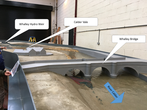
Gravel levels within the River Calder have previously been monitored and maintained when necessary under Whalley Bridge. A physical model representing the River Calder, produced by Hydrotec, has informed the thresholds and frequency of gravel maintenance. Overall, the study supports the findings of the corresponding computational model in that gravel deposits have minimal to no widespread impact on flood risk across Whalley.

Image 2: Physical Scale Model of Whalley Bridge/River Calder
Billington
Billington previously benefited from an Environment Agency Temporary Defence Management Plan (TDMP), which consisted of approx. 120m of metal A-frame barriers topped with a polyethene sheeting membrane, requiring a lead time of 24-48 hours to safely deploy.
These temporary defences offered a level of protection to homeowners in the adjacent properties along Longworth Road and Sunnyside Avenue. However, in October 2022, a review to bring all deployment plans in line with the Construction and Design Management (CDM) Regulations 2015 resulted in the withdrawal of the TDDP. The review found that the additional lead time of 48-72 hours now required to safely deploy the barriers in line with CDM regulations was unachievable in such a rapidly-responding catchment. Following this withdrawal a re-evaluation of a potential scheme to provide permanent protection to residents of Billington was undertaken. More information on this can be found in the Scheme Development/Work carried out so far section below.
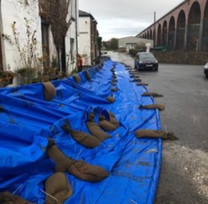
Image 3: Temporary barriers deployed at Billington
Both the EA and Lancashire County Council (Lead local Flood Authority) are involved in reviewing planning applications to ensure proposed developments do not exacerbate flood risk in these communities. Both organisations were involved in reviewing a Red Row Homes application to develop 36 properties in Billington. As a condition of receiving planning permission the developer has been required to provide appropriate compensatory flood storage, to ensure there is no additional flood risk created by the development footprint. This has been achieved by setting aside a designated area to store floodwater that would have otherwise been displaced by the development. More information on this development can be found on the Ribble Valley Borough Council planning portal under Ref:3/2021/0205.
Scheme Development/Work Carried Out So Far
Since 2015, the EA have undertaken a number of assessments to determine whether a capital funded flood risk management scheme (FRMS) could be delivered in Whalley and Billington. Initial plans for a Whalley FRMS started to be developed with local partners following the December 2015 flood event. A Strategic Outline Case (SOC) was first completed in 2018, this suggested that a combination of low-level flood walls along the River Calder and some minor works to King Street culvert would be the most appropriate solution to better protect Whalley from flooding.
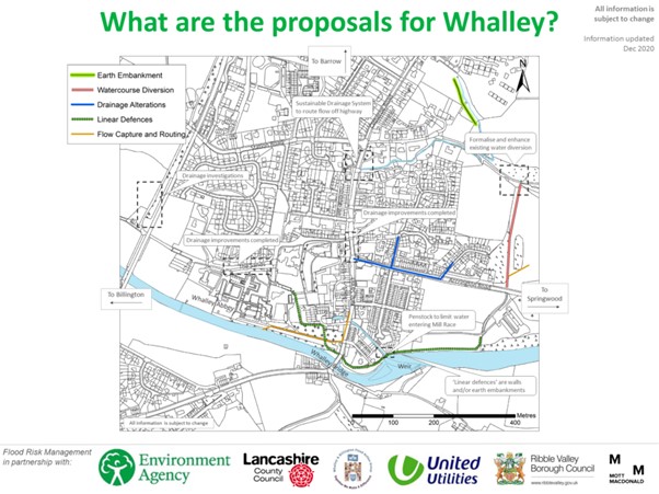
Further work to produce a more developed Outline Business Case (OBC) in 2019 sought to refine the potential defence alignment, along with fully exploring costs and available funding in line with the EA’s Partnership Funding rules. This assessment determined additional, and more substantial, defences would be needed to sufficiently protect approx. 190 properties in Whalley without increasing flood risk to others. This preferred combination of defence interventions can be seen in the image below.
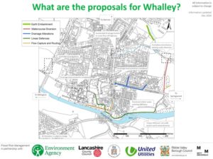
Image 4: A representation of the defences under consideration for Whalley during the 2019/20 OBC
The OBC determined the estimated Whole Life Cost of the proposed Whalley scheme was approx. £8.1M. The main source of funding available to the Environment Agency for flood defence schemes is Grant in Aid (GiA). The amount of GiA eligible towards any scheme is based on a pre-determined formula that considers the number of households protected, the estimated value of damages being prevented and other benefits a particular project would deliver e.g. environmental improvements. At the time of the OBC a sum of £3.2M was available from central government via the Grant in Aid funding calculator, leaving a funding gap of approx. £5M. As there were no viable alternative sources to bridge this significant funding gap the scheme was placed ‘on hold’ in 2020.
The EA routinely revisit previous assessments as new guidance and information emerges over time. In 2023 updated hydrological data in the wider catchment suggested an increase in predicted flows on the River Calder. The Environment Agency undertook a new feasibility review throughout 2023/24.
The EA’s project team reviewed the viability of a scheme for both Whalley and Billington. Analysis reused data from previous studies and supplemented this with up-to-date knowledge and guidance on hydrology updates, climate change allowances, benefits, and Whole Life Costs. The findings of this feasibility review had differing implications for Whalley and Billington:
- Updates to hydrology show that the frequency of flooding is greater than previously understood, with increases in flow estimates of around 30-45%.
- The amount of Grant In Aid funding the EA could obtain from central government to pay for the scheme had risen from £3.2M in 2019 to £7.5M in 2024.
- However, the estimated Whole Life Costs of delivering has also risen, increasing significantly from £8.1M in 2019 to £16.9M in 2024.
Alternative funding was explored to overcome this funding gap of approx. £9M, however bids to various funding sources proved unsuccessful. With this initial £16.9M being a best-case estimate, and any final cost likely to be even greater, the decision was made in 2024 to place the Whalley FRMS ‘on hold’ until the funding gap can be filled.
The FRMS will remain ‘on hold’ until project appraisal or funding guidance changes significantly, or substantial partnership funding contributions become available to bridge the present funding gap. The EA will continue to monitor and explore these opportunities and work with partners to manage flood risk in the community.
In the interim, Lancashire County Council are exploring a potential study into managing surface water flooding in Whalley by assessing whether Natural Flood Management methods in the wider catchment can help manage flows into Wiswell Brook prior to entering King Street Culvert.
- Updates to hydrology show that the frequency of flooding is greater than previously understood, with increases in flow estimates of around 30-45%.
- The amount of Grant in Aid funding the EA could obtain for a stand-alone Billington FRMS is £1.2M.*
- The anticipated total Whole Life Cost of a FRMS estimated to be approx. £3M* in 2024.
*These figures are based on information produced during the early-stage appraisal work carried out thus far. These may be subject to change as the project develops and existing constraints are explored in more detail.
Throughout FY 2024/25 the Environment Agency continued to develop a Billington FRMS in line with existing appraisal rules. These rules required the Environment Agency to assess and compare a range of potential solutions against defined criteria, before deciding on an agreed short-list of preferred options. Initial ecology surveys of the area were also carried out to determine potential project constraints.
The continued development of this scheme throughout FY2025/26 relied on an allocation of approx. £1.2m of Grant in Aid funding, in addition to a further contribution of approx. £1.8m from supporting funding streams. Regrettably, the scheme has been unsuccessful in attracting funding from either of these sources for the upcoming financial year. This funding shortfall has meant planned work must be placed on hold during FY 2025/26.
The proposed Billington FRMS will continue to remain eligible for approx. £1.2m of GiA funding under existing PF funding rules and the Environment Agency are committed to bidding for these funds to be allocated in FY2026/27 to enable the scheme to progress. Funding bids for eligible FRMS for next year will be submitted in Spring 2025.
A strategic review of the Partnership Funding (PF) Criteria for FRMS is expected over the next 12 months. The Environment Agency remain hopeful that this temporary pause in the project will allow the Billington FRMS to benefit from any changes in future Partnership Funding rules.
The community of Billington remains a local priority for the Environment Agency who will continue to work with partners and local stakeholders to manage flood risk accordingly.
Community flood resilience
The Whalley & Billington Flood Action Group has worked hard to improve community resilience. This includes, but is not limited to, communications displaying a strong presence on social media, preparations prior to heavy rainfall and action during/after flooding.
The Group also oversee the management of a level gauge at the point where Wiswell Brook enters King Street Culvert, assisting in ensuring the adjacent debris screen is cleared when necessary to reduce flood risk. For more details regarding the Flood Action Group please visit, https://whalleyandbillingtonfloodactiongroup.wordpress.com/.
Flood Alerts and Warnings continue to be monitored and issued. Community members at risk of flooding are encouraged to sign-up for these at https://www.gov.uk/sign-up-for-flood-warnings.
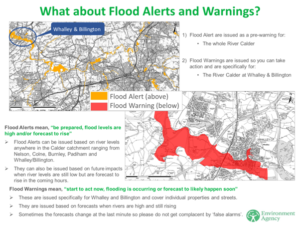
Image 5: Map showing the flood alerts and warnings in place for Whalley
More information regarding flood resilience can be found at https://flood-warning-information.service.gov.uk/what-to-do-in-a-flood.

Image 6: Prepare, Act, Survive response protocol