The proposed schemes on these pages are currently still in the appraisal stage meaning funding has not been secured. There is therefore no guarantee that these schemes will secure funding and progress to a completed flood scheme. For more information on how Flood Risk Management Schemes are funded and delivered, please visit our dedicated page here.
Information on this page has been provided by the Environment Agency and was correct at the time of upload. The Flood Hub is not responsible for any information held on this page. For any enquiries, see the Contact section of the page.

These pages describe work the Environment Agency (EA) is undertaking to reduce flood risk in areas of Carlisle adjacent to the River Caldew; this includes communities in the Denton Holme, Caldewgate, Shaddongate and Willowholme areas of the city. This is part of the EA’s ongoing work to reduce and manage flood risk across the City of Carlisle.
This area of the city is at risk of flooding from the River Caldew. Flooding in this area can occur directly as a result of extreme flood flows in the River Caldew, or in some areas, indirectly due to high flows in the River Eden which lead to correspondingly high levels on the lower reaches of the River Caldew.
Further information on the areas affected by this scheme and the causes of flooding in this area can be found here.
After Storm Desmond in 2015, a study was undertaken which looked into ways of reducing flood risk across the city. At this time, the most feasible option focused on improvements to the river channel and existing flood defences. Recent work has shown that this is no longer a viable option to further reduce flood risk in this area of Carlisle and the EA are unable to continue investing in this option.
Furthermore, there have been several recent updates to the methods that the EA use to assess flood risk. This includes future flood risk based on climate change predictions. There have also been changes to the ways the EA can apply for funding.
Further information on the work the EA have undertaken in this area since Storm Desmond can be found here.
In order to explore the best possible solutions, the EA have secured funding to investigate a range of options that have not been possible to date. Over the next 18 months, the EA will be undertaking a series of studies, which they will refer to as feasibility assessments. The EA will assess a series of new options with the aim of providing long term, and climate resilient, flood risk management for this area of the city.
You can find out more information about the work undertaken to date, and the EA’s ambitions for the Caldew Flood Risk Management Scheme here.
The River Caldew and Willowholme flood cell is the focus of the Caldew Flood Risk Management Scheme. The area comprises the floodplains on both banks of the River Caldew, as well as the left bank of the River Eden, and includes approximately 1,700 properties at risk of flooding.
There are two main causes of flooding in this area. The risk comes from the two largest rivers: the River Caldew and the River Eden. The differing sizes and locations of the catchments feeding these two rivers means that a flood event will typically affect one watercourse more than the other.
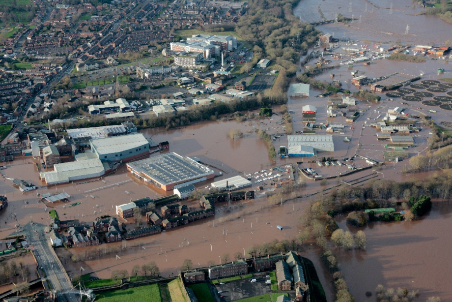
This can be seen in the events of recent years. For example, the devastating floods in 2015 resulted in the largest ever recorded flows on the River Eden through Carlisle, resulting in widespread overtopping of the River Eden flood defences. In comparison, flows in the River Caldew during this event, whilst still very large, were not as exceptional as those on the River Eden and the River Caldew defences were not widely overtopped. Where they were overtopped was in the lower reaches of the river (adjacent to the Willowholme and Caldewgate areas of the city). This was a direct result of very high water levels on the River Eden.

Aerial photograph showing flooding form the lower River Caldew and River Eden during December 2015.

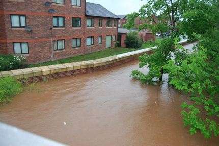
Flood defences protecting the city from flooding during the highest recorded flows on the River Caldew in June 2012.
The largest flows ever recorded on the River Caldew were in June 2012. The flood defences in this event performed well and extensive flooding to the city was avoided. In comparison, the flows on the River Eden at Great Corby (upstream of Carlisle) during this event were only approximately a fifth of the peak flow recorded following Storm Desmond.
Looking at both rivers, it is flooding from the River Caldew that has the potential to affect far more properties in this area of Carlisle. However, it is important to recognise that it was the River Eden which led to the flooding in 2015. Many of the properties which flooded in 2015 as a result of exceptionally high flows on the River Eden could also flood from the River Caldew, it if were to overtop its defences.
The Caldew and Willowholme flood cell also includes the lower reaches of Parham Beck and Dow Beck as well as the Little Caldew. The Little Caldew is a historic mill stream fed partially from the River Caldew (via a controlled off take upstream of Holmehead Weir) and partially from other watercourses and drainage systems that discharge into it. Under normal flow conditions, the Little Caldew flows back into the River Caldew under gravity just downstream of the The Maltings. However, during flood conditions, when high river levels on the Caldew prevent this, the EA operate a pumping station in order to maintain the discharge into the River Caldew and close the sluice at Holmehead Weir to minimise the inflows to the Little Caldew. The flooding that occurred during December 2015 and affected the downstream reach of the Little Caldew was the result of overtopping of the flood defences along the River Caldew and was not caused by the Little Caldew or it’s pumping station.
As each of these rivers affect the same connected area of floodplain, the EA need a flood scheme that addresses all these flood mechanisms. The EA would be unlikely to be able to fund a scheme which addresses the flood risk from only one of these rivers in isolation. The main reason for this is that the EA cannot claim the funding to mitigate flood risk to properties unless each potential source of flooding is taken into account.
The Caldew Flood Risk Management scheme must therefore reduce flood risk arising from high flows on both the Rivers Eden and Caldew, as well as considering other watercourses and potential sources of flooding.
The Environment Agency (EA) is currently undertaking a feasibility assessment of several options to further reduce flood risk in this area of Carlisle; these include interventions upstream of the city, designed to reduce the size of large flood flows reaching Carlisle, as well as interventions within the city.
This work builds on the EA’s knowledge and understanding of the catchment and of appropriate flood risk management interventions that the EA have developed over the years, including:
When assessing a potential intervention, the EA must not only assess its ability to reduce flood risk now and in the future but must also consider the historic and environmental importance of the river and its surroundings, the impact on adjacent infrastructure and development as well as the cost, complexity and technical viability of its construction and operation. Ultimately, for any flood risk management scheme to be delivered it must be both financially and technically viable, be able to secure the permits and permissions required by law and to be acceptable to the community and its stakeholders.
The EA project team must continuously adapt (for example as data and understanding improves or to changes in funding or legislation) and to develop options which show the most potential. This means that as the project progresses, it evolves; but the EA’s focus remains to identify and deliver interventions that reduce flood risk as quickly and efficiently as possible.
The EA will engage fully with all stakeholders as the project progresses; however, this will be during subsequent phases of work and only once the EA have identified options which are able to deliver the primary objective of reducing flood risk in Carlisle.
The EA currently anticipate the feasibility study concluding in Spring 2025. Following this the EA hope to be able to identify a preferred combination of options around which can be developed into a business case and detailed designs. The measures that the EA are able to progress and therefore the timeframe for delivery will be dependent on the conclusions of the current feasibility study.
If you would like to provide any feedback on the information provided or would like to contact the Carlisle Flood Risk Management Scheme project team please use the following email address: [email protected].