The proposed schemes on these pages are currently still in the appraisal stage meaning funding has not been secured. There is therefore no guarantee that these schemes will secure funding and progress to a completed flood scheme. For more information on how Flood Risk Management Schemes are funded and delivered, please visit our dedicated page here.
Information on this page has been provided by the Environment Agency and was correct at the time of upload. The Flood Hub is not responsible for any information held on this page. For any enquiries, see the Contact section of the page.


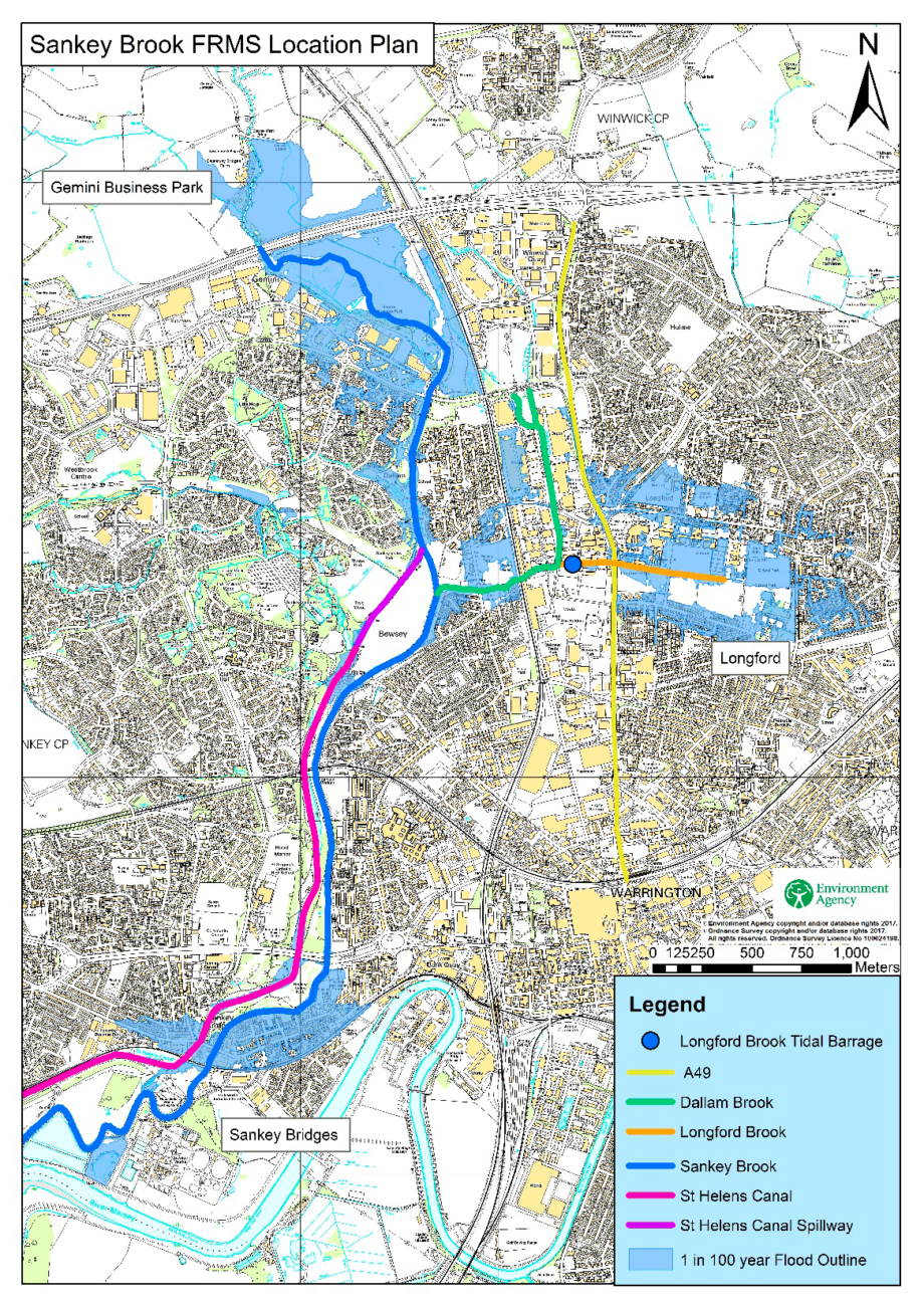
The Sankey Brook Flood Risk Management Scheme (FRMS) aims to reduce the flood risk to homes and businesses from Sankey Brook, Dallam Brook and Longford Brook in Warrington. There are more than 1,700 residential properties currently at risk of flooding during a 1 in 100 year flooding event (1% chance of occurring in any given year). The onset of flooding for some of these properties is as frequent as once every 10 to 20 years. Key areas include Sankey Bridges, Dallam, Bewsey and Callands.
The Environment Agency will be working in partnership with Warrington Borough Council, United Utilities, the Department for Education, and the North West Regional Flood and Coastal Committee.
This project is a recommendation from the Warrington Flood Risk Management Strategy (dated 2010).
Linking to this Strategy, to date the Environment Agency have delivered the River Mersey Flood Risk Scheme in Warrington which provides flood protection to over 2,000 properties and businesses along the River Mersey. For further information about this scheme can be found here: https://thefloodhub.co.uk/warrington-flood-risk-management-scheme/.
We also completed, in December 2023 the engineering works on the Penketh and Whittle Flood Risk Management Scheme; and in Spring 2024 will be finalising the planting and landscaping works. This project has been delivered in partnership working with Warrington Borough Council and aims to reduce flood risk to 221 properties from Penketh and Whittle Brooks. More information about this scheme can be found here: https://thefloodhub.co.uk/penkethandwhittlefrms/.
Flood risk is predominantly from fluvial and surface water within the proposed area of interest. There is a tidal influence from the Mersey that can affect Sankey Brook and its tributaries.
There is a history of flooding in this area; notably 2000, 2003, 2008, 2012, 2019 and most recently during the Storm Christoph flood event of January 2021.
There are a number of potential flood risk measures that are being considered as the Environment Agency develop a preferred solution for the Sankey Brook FRMS. These include:
Environmental benefits and opportunities are being considered throughout the development of the scheme. The Environment Agency want to ensure that the Sankey Brook Flood Risk Management Scheme enhances the environment by creating or improving habitats in the area, improving recreational and amenity areas, and delivering tree planting and other similar opportunities which will develop and enhance the character of the area.
In developing the proposals the Environment Agency will look to minimise the carbon emission of their work to support Environment Agency aspirations and objectives.
The funding from central government for managing flood risk in England is known as ‘Flood Defence Grant in Aid’. This will be the primary source but the Environment Agency are also actively working with key partners including the Department of Education, the Northwest Regional Flood and Coastal Committee and other bodies to identify other potential funding streams for this Scheme.
| Milestone | Date |
| Completion of Detailed Design including submission of scheme planning application | Spring 2030 |
| Submission to request approval to undertake construction works | Spring 2030 |
| Approval to proceed with construction works | Summer 2030 |
| Start of Construction Works | Autumn 2030 |
| Completion of Construction works | Spring 2033 |
*Above dates are current best estimate and maybe subject to change.
Last updated: January 2026
Environmental and ecological surveys are complete, providing the baseline needed to assess impacts and benefits of the proposed Flood Risk Management Scheme.
Multi Agency Community Drop in details:
The Environment Agency has now contracted with Frameworks Design Consultants Jacobs to undertake the first phase of the design stage for the Sankey Brook Flood Risk Management Scheme (FRMS). This first phase of the design will focus on refining the outline design for the preferred scheme option; clarifying design assumptions and uncertainties; and mitigating delivery risks.
As we continue to progress this work you will see increased site activity in the area over the coming months. This is because of a number of surveys that need to be undertaken. These include bridge inspections and assessments, environmental and ecological surveys, and also the gathering of ground level information. This on-site presence will cover the entire study area ie Sankey, Dallam and Longford Brooks from upstream of the M62 down to the River Mersey confluence. All personnel on site will carry appropriate letters of identification to confirm that they are undertaking works on behalf of the Environment Agency to progress the Sankey Brook FRMS.
Should you have any queries or concerns and would like to speak to a member of the project team, please email [email protected] or if you do not have access to email, please call 02030 250495.
The Outline Business case for the Sankey Brook FRMS was approved in October 2024, this approval gave the project team authorisation to progress to the design stage of the project. £1.5 million of funding has been secured for the current financial year (25/26) and the Environment Agency are currently in the process of getting into contract with their design consultant. This contract is to undertake the first phase of the design stage which includes the further development of the outline design of the preferred scheme option.
The Environment Agency have submitted a bid for funding (£2.4muillion) for next financial year (26/27) and subject to this being secured, they aim to complete the outline design development by Christmas 2026. Following the refinement of the outline design they will progress to the detailed design stage and aim to submit the Full Business Case (FBC) for approval in Spring 2029. Subject to the approval of the full business case, construction works are currently scheduled to commence in Autumn 2029. There currently remains an overall project affordability issue that the project team will be looking to address over the coming year. They hope the planned changes to the Grant in Aid funding process will help with this.
The Environment Agency carried out vegetation clearance along Longford Brook to investigate whether it improves water flow. Before and after images can be seen below.
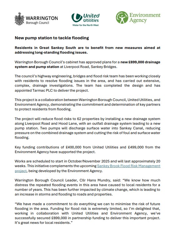
Please click here to download the update about the new pump station being put in place to tackle flooding.
This consultation is now closed and the information below was correct at the time of consultation.
The Sankey Brook Flood Risk Management Scheme (FRMS) is the third and final project to come out of the Warrington Flood Risk Management Strategy, which was produced by the Environment Agency (EA) in 2010.
This project is looking to reduce the risk of flooding from all sources within the study area. This includes fluvial and tidal flood risk from Sankey Brook, Dallam Brook and Longford Brook as well as surface water flood risk to local properties.
Since the 1950s, the study area has experienced flooding on numerous occasions, affecting residential and commercial properties, local schools and nurseries, and transport links such as Winwick Road (A49). There are over 1700 residential properties currently at risk of flooding during a 1 in 100 year flooding event (1% chance of occurring in any given year). The onset of flooding for some of these properties is as frequent as once every 10 to 20 years.
Significant flooding events occurred in 2008, 2012, 2015 (Storm Desmond) and most recently in January 2021 (Storm Christoph).
The EA has permissive powers under the Water Resources Act to undertake works to reduce flood risk from watercourses designated as “Main River”. Working in collaboration with their project partners – Warrington Borough Council (WBC) and United Utilities (UU), the EA is currently undertaking an appraisal study to identify measures to reduce flood risk from all potential sources.
Any proposed works to reduce flood risk must be shown to be economically viable (i.e. the benefits from doing the works must be greater than the costs of delivering the works) and affordable (i.e. there must be sufficient funding available to cover the cost of the proposed works). The standard of scheme that can be promoted will be governed by these two primary investment requirements.
Storm Christoph (January 2021) was the most significant event in recent times and resulted in wide-spread flooding and damage to residential and commercial property and key infrastructure within the study area.
The flood event highlighted the different flooding mechanisms and sources. It reinforced the need for the EA, WBC and UU to work in partnership to deliver a comprehensive flood risk management scheme that delivers the best outcome possible to the local community.
Since Storm Christoph there have been actions undertaken by the three partners to reduce flood risk and the associated stress and anxiety.
Maintenance activities including vegetation clearance around key assets, blockage and debris removal in the river channels, and channel side vegetation management on Sankey, Dallam and Longford Brooks within the Warrington area. Works were also undertaken to the overflow channel from Sankey Brook to Sankey Canal to remove mature and fallen trees; this is to ensure the unobstructed conveyance of water when this asset operates. A sandbag wall has been constructed in the vicinity of Rostherne Close to block a potential flow path from Sankey Brook.
Ongoing investigations, monitoring and improvement works have been undertaken to mitigate surface water risk within a number of communities.
The EA continue to work with their key partners to identify and discuss contingency opportunities and measures that could be deployed ahead of the Capital Scheme delivery; and will keep you updated on this progress.
A wide variety of mitigation measures detailed in the table below have been considered to reduce the risk of flooding within the study area. These include:
The viability and effectiveness of each measure has been assessed and then the flood mitigation measure has been either “Accepted” or “Rejected”.
A summary of the assessment of the key flood risk mitigation measures is provided below:
| Flood Mitigation Measure: | Comments: | Decision: |
| Slow the Flow Works | Limited potential. Minimal flood risk management benefit. | Rejected |
| Attenuation – Off Line Flood Storage | Adverse environmental impact due to disconnection of watercourse from adjacent flood plain. | Rejected |
| Attenuation – On Line Flood Storage | Provides good flood risk management benefits whilst maintaining watercourse / flood plain connectivity. | Accepted |
| Linear Defences (walls and embankments) | Provides good flood risk management benefits, but acceptable defence height might limit standard of protection that can be provided. | Accepted |
| Improve Channel Conveyance | Costs to upsize culverts and bridge openings is prohibitive. Flood risk management benefits are negligible during more extreme events. | Rejected |
| Refurbish Longford Barrage | Longford Barrage is a critical flood risk management asset which provides benefits to property adjacent to Longford Brook by keeping water levels in Longford Brook low. | Accepted |
| Install New Barrages | New barrages were considered at the confluence of Sankey Brook with the River Mersey and at the confluence of Dallam Brook with Sankey Brook. The flood risk management benefits were significantly outweighed by the costs and adverse environmental impacts. | Rejected |
| Flood Relief Channel | Consideration was given to diverting more water into the canal and to constructing a bypass channel downstream of Sankey Bridges. Flood risk management benefits are negligible during more extreme events. | Rejected |
| Residual Surface Water Mitigation Measures | There will continue to be surface water flooding issues where drains can’t discharge due to high water levels in the brooks. Localised measures will be required in these problem areas to provide comprehensive flood alleviation to these communities. | Accepted |
| Improved Flood Warning | Widespread flood warning measures are already in place. There are no identified improvement measures that would offer additional benefits. | Rejected |
The “Accepted” flood risk mitigation measures have then been combined to produce a short list of scheme options which will now undergo further detailed appraisal.
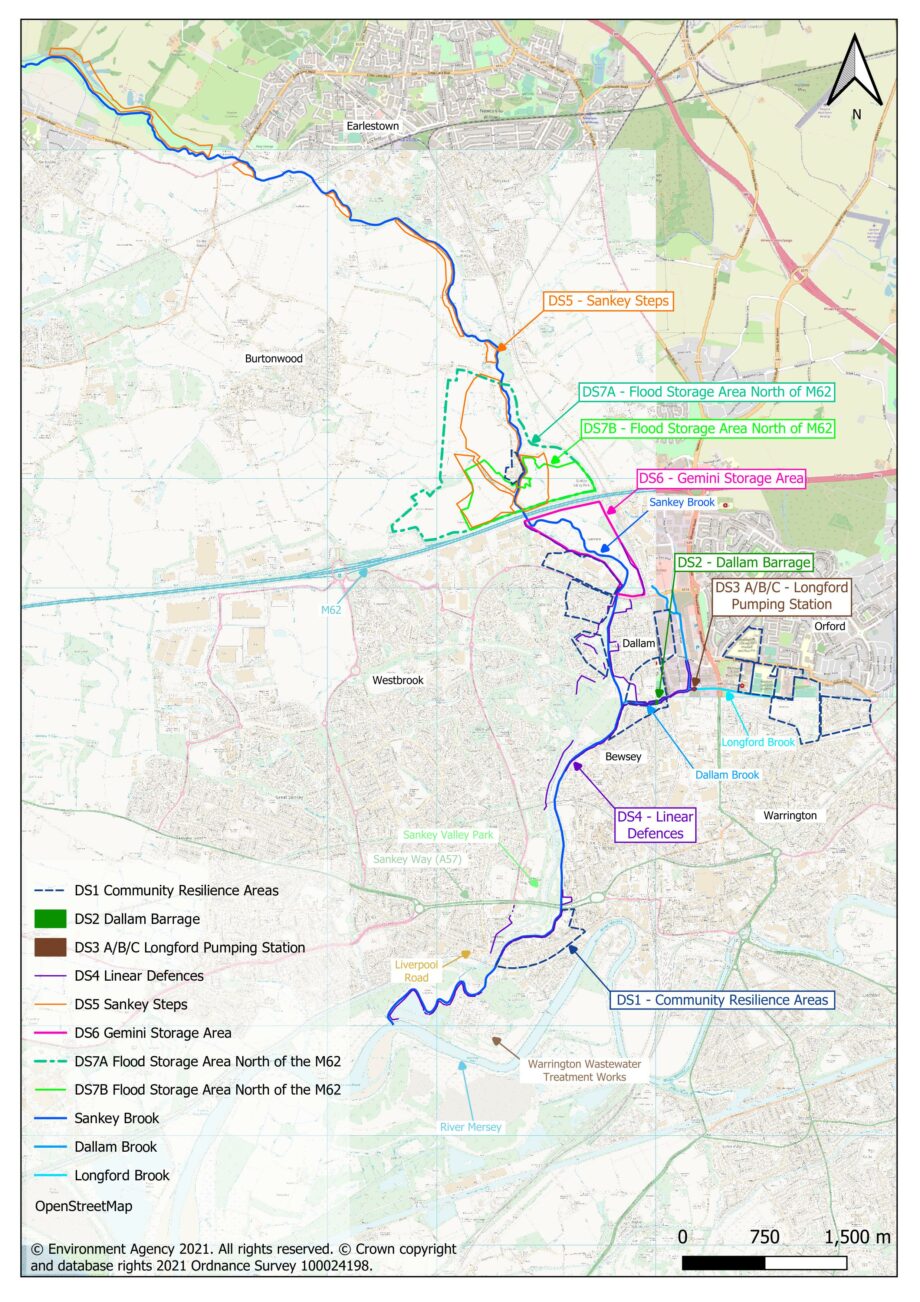
As part of their Project Appraisal process the EA are required to consider the Do-Nothing and Do-Minimum scenarios.
The Do-Nothing Option assumes that no further action is taken to mitigate flood risk within the study area and existing assets are left to deteriorate. This option provides a base line against which the benefits and economic viability of any positive action and intervention can be measured against.
The Do-Minimum option considers the costs and benefits of doing the bare minimum to operate and maintain existing assets and continue with routine flood risk management operations to maintain the existing standard of protection. This option provides a benchmark against which the additional costs and benefits of any improvement option can be compared.
In addition to the Do-Nothing and Do-Minimum options, a number of Do Something options have been identified which would improve the standard of flood protection within the study area. All three of the Do Something options include the refurbishment of Longford Barrage and measures to address residual surface water issues. They differ from each other in terms of how much reliance each option places on linear defences and upstream flood storage (attenuation).
The standard of flood protection that can be provided by linear defences (walls and embankments) will likely be limited by the maximum height of defence that is acceptable to local residents within the community.
The effectiveness of upstream flood attenuation will be dictated by the availability and appropriateness of potential flood storage areas. Flood storage areas currently under consideration include upstream of the M62 and the Gemini washlands area.
The Short List of Options currently undergoing detailed appraisal are:
| Do Nothing (DN) |
| Do Minimum (DM) |
| Do Something 1 (DS1): Upstream attenuation + surface water mitigation measures + Longford Barrage refurbishment |
| Do Something 2 (DS2): Linear defences + surface water mitigation measures + Longford Barrage refurbishment |
| Do Something 3 (DS3): Upstream attenuation + linear defences + surface water mitigation measures + Longford Barrage refurbishment |
A “Preferred Scheme Option” will be selected from the above short list taking into consideration technical effectiveness, economic viability, affordability, environmental acceptability and sustainability.
Following the selection of the “Preferred Scheme Option” the optimum standard of flood protection that can be justified will then be established.
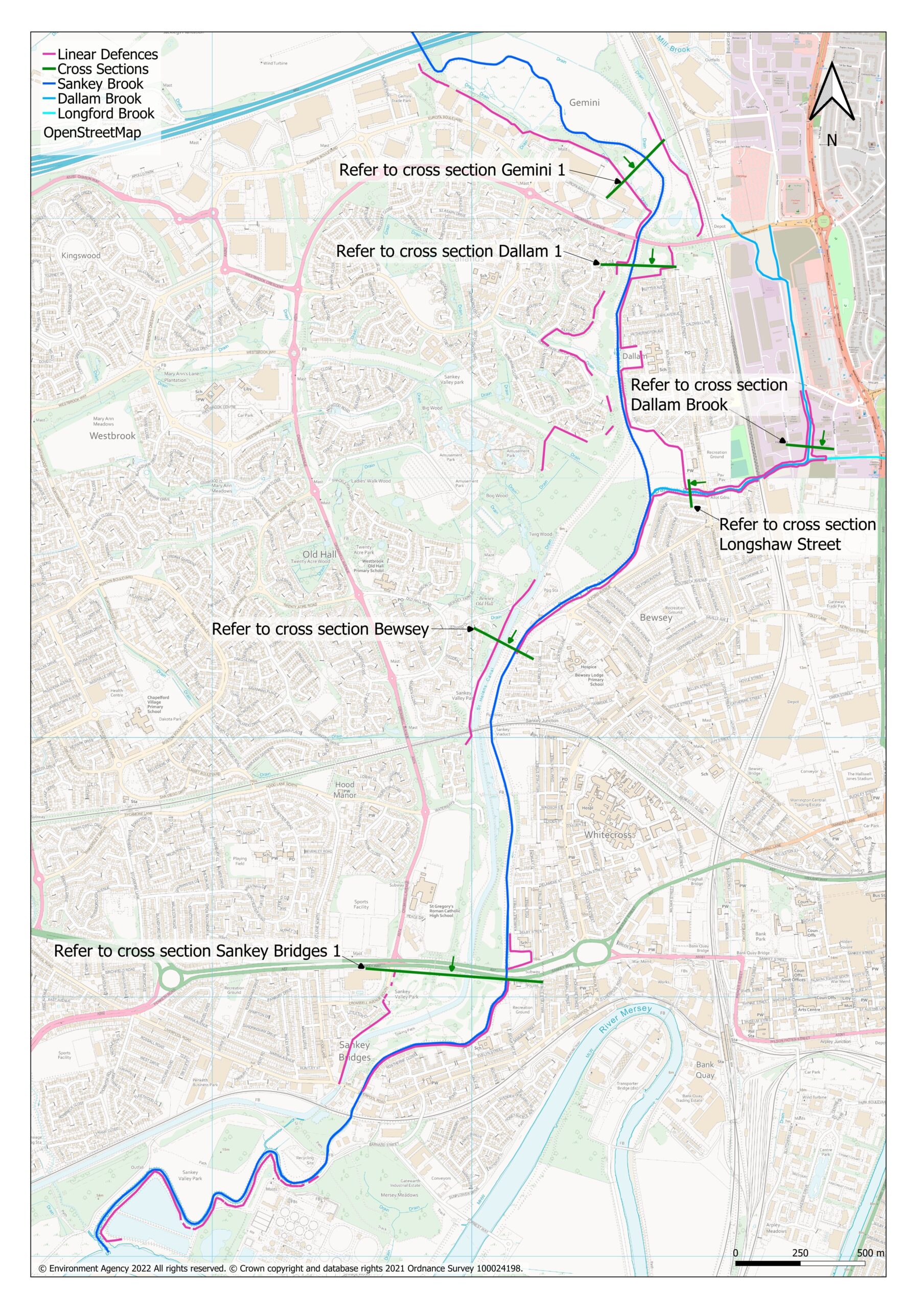
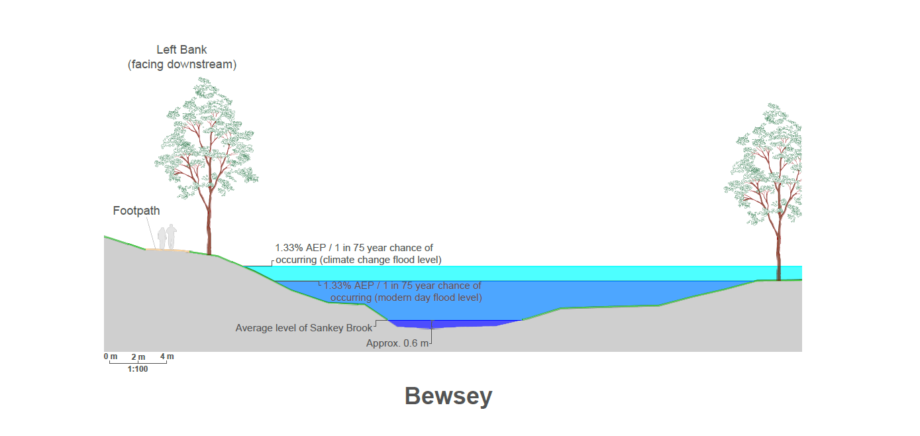
Click here to download cross section of Bewsey – left bank
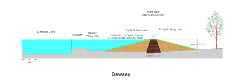
Click here to download cross section of Bewsey – right bank
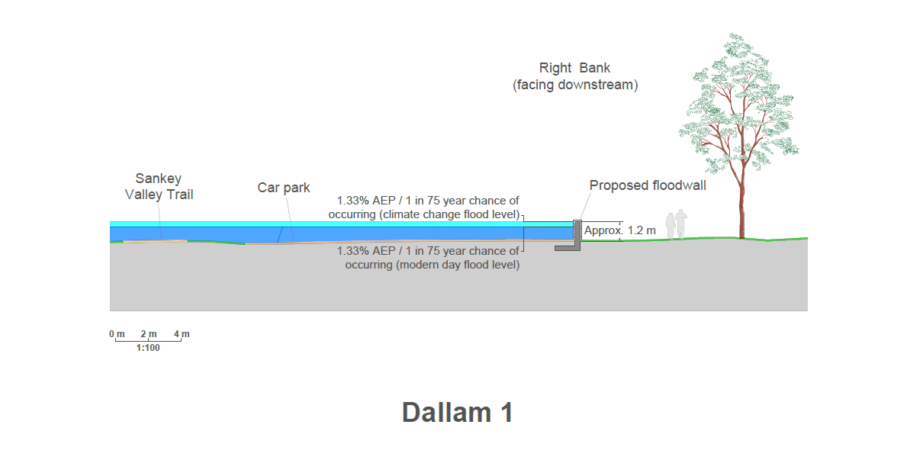
Click here to download cross section of Dallam 1 – right bank

Click here to download cross section of Dallam – left bank
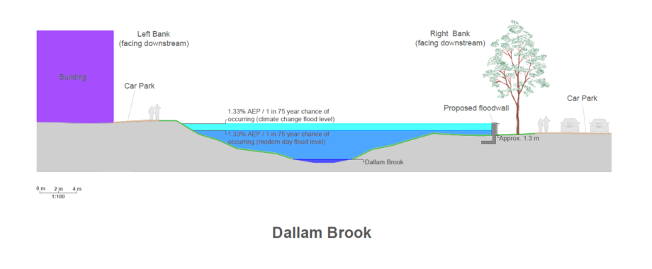
Click here to download cross-section of Dallam Brook
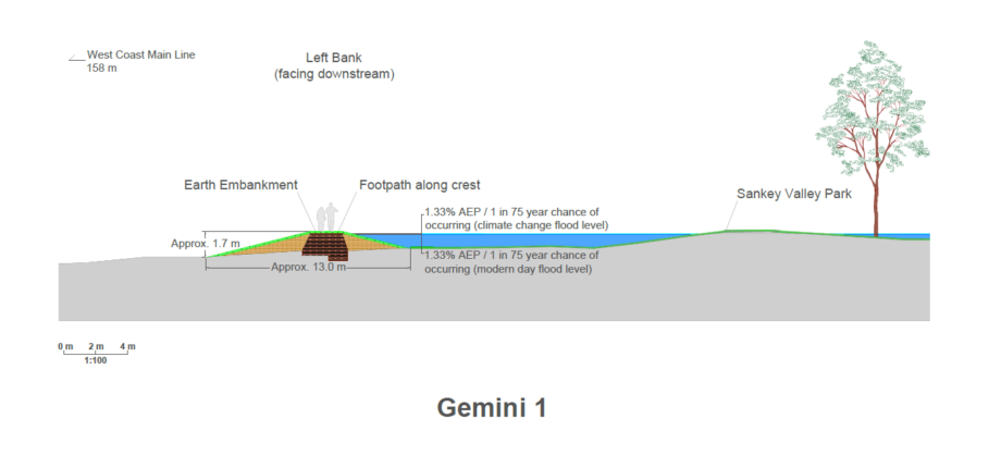
Click here to download cross section of Gemini 1 – left bank
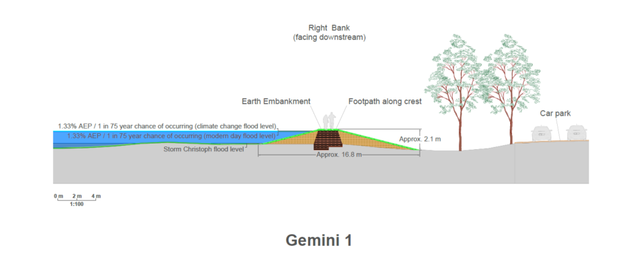
Click here to download cross section of Gemini 1 – right bank

Click here to download cross section of Longshaw Street
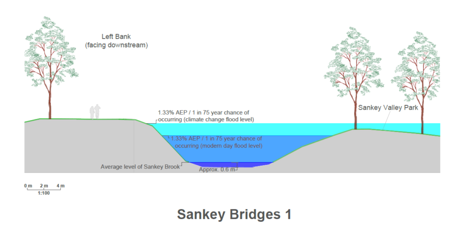
Click here to download cross section of Sankey Bridges 1 – left bank
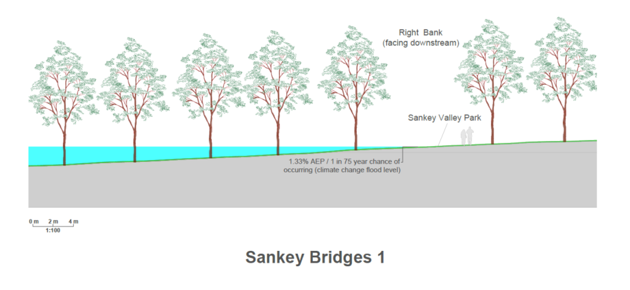
Click here to download cross section of Sankey Bridges 1 – right bank
The Sankey Brook FRMS will also look to deliver wider scheme benefits including:
Illustrative examples are shown below.
The EA also has a role to deliver measures to help the watercourses reach ‘good ecological potential’ under the Water Environment (Water Framework Directive) Regulations.
Alongside the benefits to communities and the local economy through reducing flood risk – these elements will help the FRMS contribute to nature recovery and wider benefits for environment and society, in line with the objectives of the national Flood and Coastal Erosion Risk Management Strategy for England, and the objectives and aspirations of the EA, partners and key stakeholders.
A ‘landscape vision’ for the Sankey FRMS benefit area through Warrington has been established – the overarching aim of this is to conserve and enhance the environment.
Reconnecting the floodplain and creating wetlands, creating habitats and increasing biodiversity, improving the environment of the river and contributing to the Water Framework Directive.
Potential focal point / artwork, seating, footpaths, signage, and interpretation. Explore opportunities to enhance existing species rich grassland.
Canal heritage signage, interpretation, viewing area along footpath network.
The EA’s objective is to deliver a comprehensive Flood Risk Management Scheme that reduces risk from all sources to the Community. This is both the fluvial and tidal risk from Sankey, Dallam and Longford Brooks and the surface water risk within this area.
Collaborative working with key partners is essential throughout to ensure the necessary partnership funding and successful delivery of this scheme. In addressing the flood risk problem (as previously discussed above) all partners are proactively working together, with established working groups and technical workshops to discuss the options that deliver the best outcome to the community.
The EA’s partners include Warrington Borough Council (WBC), United Utilities (UU), Regional Flood & Coastal Committee (RFCC) and the Department of Education (DfE).
In working with the DfE the EA are connecting with both local schools and colleges that are within the study area to promote flood risk as part of their curriculum. This provides platform for students to learn about civil engineering and the challenges of mitigating flood risk in the current climate.
Previously on the River Mersey, Warrington Flood Risk Management Scheme the EA engaged with local schools at each phase of the project and held a series of artwork competitions – winning artwork was incorporated into the finished flood defence walls – examples are shown below. This was a great success within the local community and promoted a ‘real sense of support and ownership’ of the completed scheme. This could be considered for the Sankey Brook FRMS.


As previously discussed, the EA’s ambition is to deliver a comprehensive scheme to address flood risk from all sources and to achieve this, the timeline for the scheme has recently been reviewed. Working with key partners Warrington Borough Council (WBC) and United Utilities (UU), the project team need to fully understand the residual surface water flooding and deliver a comprehensive scheme integrating appropriate measures alongside the fluvial and tidal mitigation.
The complexity of a scheme of this nature has led to some movement in the EA’s milestones for the project. The EA now anticipate approval of their preferred solution and outline business case by July 2023. At this stage of scheme development, the EA will also need to demonstrate a clear funding strategy and secure funding commitments from key partners. The project team will then work towards to the detailed design and the final business case approval, with construction beginning the following month.
Programme milestone dates:
Click image to make it bigger
Thank you for reading through the information the Environment Agency (EA) have presented. These questions should only take a few minutes and your valuable feedback will help inform the project team to progress to the preferred option for the scheme.
The information in this form will be passed by The Flood Hub to the Environment Agency.
If you wish to submit your contact details, The Flood Hub will pass the information to the Environment Agency and The Flood Hub will not use this information to contact you.
The Environment Agency will keep the contact details you provide until 31 December 2022 unless you ask to be removed from the mailing list.
The Environment Agency will not share your details with any other third party without your explicit consent unless required to by law.
If you no longer wish to receive these emails, let the Environment Agency know at any time by contacting them at [email protected].
The Environment Agency is the data controller for the personal data you provide. For further information on how they deal with your personal data and how to exercise your rights please see our Personal Information Charter or contact us for further details at [email protected].