The proposed schemes on these pages are currently still in the appraisal stage meaning funding has not been secured. There is therefore no guarantee that these schemes will secure funding and progress to a completed flood scheme. For more information on how Flood Risk Management Schemes are funded and delivered, please visit our dedicated page here.
Information on this page has been provided by the Environment Agency and was correct at the time of upload. The Flood Hub is not responsible for any information held on this page. For any enquiries, see the Contact section of the page.


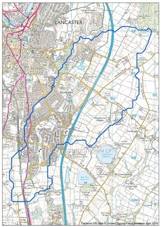
The areas of Scotforth, Hala and Bowerham in South Lancaster are heavily urbanised and experience flooding from Burrow Beck (Main River), which flows in a southerly direction throughout the area.
Over 200 properties in the area benefit from Environment Agency (EA) flood warnings and a river level gauge is located along Burrow Beck adjacent to the allotments between Wyresdale Road and Canterbury Avenue. Burrow Beck is a Rapid Response Catchment, making it challenging to provide accurate forecasting without over-warning, meaning flooding can occur in between flood warnings.
Significant flood events have occurred in September 2011, December 2015 and November 2017. More recently two separate flood events occurred less than a week apart in August 2020, during which 20-30 properties experienced flooding. At least one of these 2020 flood events was partly attributed to a blockage of the footbridge from Lentworth Drive to Gressingham Drive. The footbridge was removed and replaced with an approach ramp, reducing the risk of future blockage.
Several partner organisations have been working together to plan and implement better flood risk management in the Burrow Beck catchment. This includes the Environment Agency, Lancashire County Council, Lancaster City Council, United Utilities, South Lancaster Flood Action Group and the Lune Rivers Trust.
Following the flooding in August 2020 the Environment Agency constructed a temporary flood defence barrier along Lentworth Drive. This defence, comprised of sandbags and visqueen, proved effective in preventing flooding when tested during November 2020. To maintain the defence’s integrity the Environment Agency have replaced the components on multiple occasions whilst work was undertaken to deign a permanent defence structure.
All associated Risk Management Authorities continue to operate in their functions as statutory consultees on planning applications, this has included working alongside prospective developers to ensure proposed plans do not result in an increase in flood risk to the Burrow Beck catchment. Highbrook Homes in particular have opted to implement a range of exemplar attenuation measures within their Surface Water Management Plan, including the construction of two flood storage basins and a tiered system of swales across their intended development site off Wyresdale Road. The development’s Surface Water Management Plan can be found on the Lancaster City Council Planning Portal using reference 22/00816/FUL.
Lancaster City Council replaced the footbridge crossing Burrow Beck along Cranwell Avenue in Summer 2023, improving access to the adjacent recreation area. The footbridge now sits on new raised abutments which increase the soffit level of the bridge above the Beck. This has increased the channel capacity and reduced the risk of blockage during high flows, thereby reducing the risk of flooding to nearby properties.
Several other activities have been completed, including the construction of capital funded flood risk management schemes (FRMS) along Lentworth Drive and the continued development of a further scheme adjacent to Canterbury Avenue. More information on these schemes can be found in the respective Work Carried Out So Far & Future Proposals sections below.
The EA maintains over 2.5km of the Main River Burrow Beck channel through Scotforth, which includes maintenance checks, and management of aquatic and riparian vegetation to maintain the conveyance of the river channel. These activities are scheduled to occur twice a year, stretching from the point where Burrow Beck Crosses the junction of Cranwell and Canterbury Avenue (upstream extent) to Shirehsed Crescent (downstream extent)
Once a year, Lancaster County Council maintains the embankment on the right of Burrow Beck, along Cranwell Avenue by undertaking grass and vegetation management. The watercourse is perched in this section, meaning it sits above the surrounding land area. The Environment Agency refurbished and increased the height of the embankment in 2018 and it now provides a Standard of Protection in excess of 1-in 100 (1% AEP).
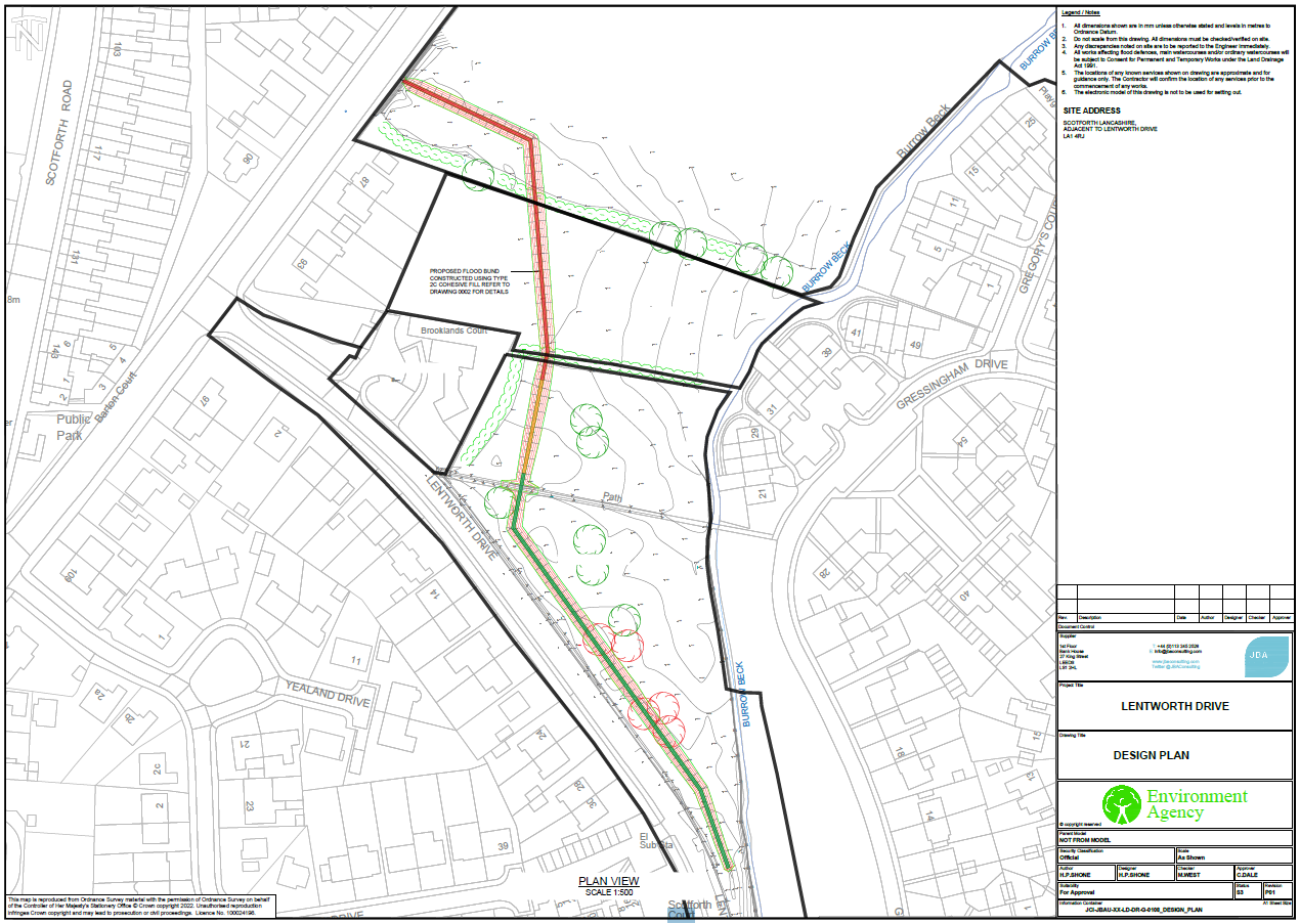
The Environment Agency and relevant stakeholders have worked to construct a permanent earth bund to replace the previous temporary defences along Lentworth Drive, affording better protection to approx. 20-30 homes, local businesses and key infrastructure as a result.
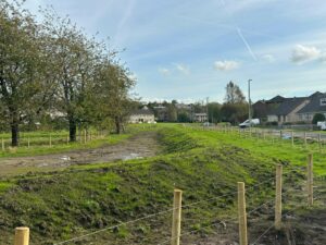
After receiving planning approval from Lancaster City Council in June 2023, a 12-week construction programme was undertaken from Aug 2023- Oct 2023. The completed formal defence will deliver a long-term reduction in flood risk to the residents of the Lentworth Drive area.
The bund varies in height between 500-900mm across the open space and provides a consistent 1 in 100-year (1% AEP) Standard of Protection. This ensures that local residents will remain suitably protected against more frequently occurring rainfall events. The layout of the defence extends North perpendicular to Lentworth Drive, before crossing through the former allotments site, and tying into higher ground in the South-West corner of Barton Road playing fields.
Positive discussions with local stakeholders ensured the completed bund had no adverse impacts on existing utilities or local services. The footpath crossing from Lentworth Drive to Gressington Drive was also successfully incorporated as part of the final design. A total of 5 trees were removed from the open space at Lentworth Drive to facilitate the construction of the bund. As part of the Environment Agency’s commitment to replacing the trees on a 1:5 ratio, 25 new native trees were planted to offset the environmental impact, along with an improved section of hedgerow to provide further biodiversity enhancement.

Alignment of permanent flood embankment at Lentworth Drive

Completed embankment along Lentworth Drive – Autumn 2023
Additional construction work was carried out in Autumn 2024 to address the routine accumulation of surface water on the Eastern side if the bund. Although this surface water ponding did not reduce the effectiveness of the bund, it did create difficulties for footpath users, especially during significant rainfall events.
A filter drain solution was installed along the toe of the bund, using a combination of gravel and geotextile material to create a permeable channel. This solution utilised the natural gradient of the land to convey surface water into Burrow Beck through a pre-cast concrete headwall. Future maintenance of the bund and the associated drainage structure will be managed by Lancaster City Council and Lancashire County Council as respective landowners.
The Environment Agency and relevant stakeholders are also working to design an additional FRMS which would offer further flood risk reduction to the residents of the Canterbury and Cranwell Avenue area.
The proposed scheme, costing an estimated £3M, would provide better protection to approx. 40 properties by constructing a linear defence to the rear of properties along Canterbury Avenue, extending up into the Cork Road allotment site.
This conveyance improvement scheme plans to address the existing flow path in which floodwater spills into and through the western floodplain along Canterbury Avenue and Cranwell Avenue. Although the exact design of the defence has not been finalised it is intended to offer a 1 in 20-year (5% AEP) Standard of Protection.
Continued development of this scheme has been made possible due to the availability of the Frequently Flooded Community (FFC) allowance. This funding is available to qualifying schemes where affected communities have experienced flooding to 10 or more properties, on two separate occasions, in the last 10 years. The Environment Agency have secured a FFC contribution of £650,000 towards this scheme.
A substantial project appraisal has been conducted, in line with the Environment Agency’s appraisal guidelines for FRMS. An Outline Business Case produced in 2022 sought to compare potential solutions with the objective of identifying a preferred option. The preferred option of a linear defence was selected due to economic viability and fundability as well as its ability to reduce flood risk in a robust, sustainable and acceptable manner.
As part of the next project phase appointed design consultants will work to further define the preferred option. To inform this design phase supporting work has been carried out during Winter 2024, consisting of vegetation clearance, ground investigation studies and topographical surveying.
Members of the EA project team have continued to engage with affected landowners as well as other local stakeholders relevant to the scheme. Engagement will continue throughout the design phase and a wider public consultation will be held prior to the submission of a required planning application.
It is not possible to provide a definite start-date for the construction of the FRMS, as this depends on a number of factors including; funding availability, business case approvals, ground conditions, design complexity, construction costs and planning permission. However, it is the Environment Agency’s aspiration that the detailed design element will be completed by Summer 2025. Updates on project development shall continue to be provided to the local community via newsletters and The Flood Hub.
No extra downloads at the time.
No extra downloads at the time.
Lentworth Drive Flood Risk Management Newsletter October 2023
Lentworth Drive Flood Risk Management Newsletter August 2023
Lentworth Drive Flood Risk Management Newsletter August 2024
Partners
Report highway flood issue using ‘Love Clean Streets’ website: Report flooding and drainage – Lancashire County Council
(Lancs County Council) or 0300 126 6701
Report public sewer flood issues: 0345 672 3723 (United Utilities)
Risk to life: 999
